Photographic Print > Europe > Republic of Ireland > Maps
Photographic Print : MAPS / BRITAIN / 1763


![]()
Photo Prints from Mary Evans Picture Library
MAPS / BRITAIN / 1763
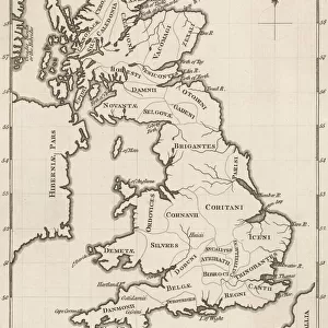
An accurate map of Great Britain and Ireland from the best authorities
Mary Evans Picture Library makes available wonderful images created for people to enjoy over the centuries
Media ID 620765
© Mary Evans Picture Library 2015 - https://copyrighthub.org/s0/hub1/creation/maryevans/MaryEvansPictureID/10074331
1763 Accurate Authorities Best Maps
12"x8" (30x20cm) Photo Print
Introducing the exquisite "MAPS / BRITAIN / 1763" print from Mary Evans Picture Library, exclusively available through Media Storehouse. This striking historical map offers a captivating glimpse into the past, depicting an accurate representation of Great Britain and Ireland as it was known in 1763. Meticulously sourced from the finest authorities, this vintage map is a must-have for history enthusiasts, educators, and anyone with a passion for the intricacies of cartography. Bring the rich history of this region to life in your home or office with this beautifully detailed and authentic print. Order now from Media Storehouse and let the story of Britain and Ireland unfold before your eyes.
Ideal for framing, Australian made Photo Prints are produced on high-quality 270 gsm lustre photo paper which has a subtle shimmer adding a touch of elegance, designed to enhance their visual appeal.
Our Photo Prints are in a large range of sizes and are printed on Archival Quality Paper for excellent colour reproduction and longevity. They are ideal for framing (our Framed Prints use these) at a reasonable cost. Alternatives include cheaper Poster Prints and higher quality Fine Art Paper, the choice of which is largely dependant on your budget.
Estimated Product Size is 21.2cm x 31.4cm (8.3" x 12.4")
These are individually made so all sizes are approximate
Artwork printed orientated as per the preview above, with portrait (vertical) orientation to match the source image.
FEATURES IN THESE COLLECTIONS
> Europe
> Republic of Ireland
> Maps
> Maps and Charts
> Early Maps
> Maps and Charts
> Related Images
EDITORS COMMENTS
This stunning print captures a piece of history with an accurate map of Great Britain and Ireland from 1763. Created by the best authorities of the time, this detailed map provides a glimpse into the geographical landscape of Britain and Ireland during this significant period in history.
The intricate details on the map showcase the various regions, cities, and landmarks that were present over two centuries ago. From London to Dublin, Edinburgh to Cardiff, each location is meticulously labeled, giving viewers a sense of how these countries were structured in the past.
As we study this historical map, we can appreciate the craftsmanship and expertise that went into creating such an accurate representation of Great Britain and Ireland. It serves as a reminder of how far cartography has come since then while also highlighting the importance of preserving these pieces of our past.
Whether you're a history buff or simply fascinated by maps, this print from Mary Evans Picture Library is sure to captivate your imagination. Step back in time and explore Great Britain and Ireland as it was seen through the eyes of experts in 1763 - a true treasure for any lover of historical artifacts.
MADE IN AUSTRALIA
Safe Shipping with 30 Day Money Back Guarantee
FREE PERSONALISATION*
We are proud to offer a range of customisation features including Personalised Captions, Color Filters and Picture Zoom Tools
SECURE PAYMENTS
We happily accept a wide range of payment options so you can pay for the things you need in the way that is most convenient for you
* Options may vary by product and licensing agreement. Zoomed Pictures can be adjusted in the Cart.