Photo Mug > Maps and Charts > Early Maps
Photo Mug : VIKING MAP


![]()
Home Decor from Mary Evans Picture Library
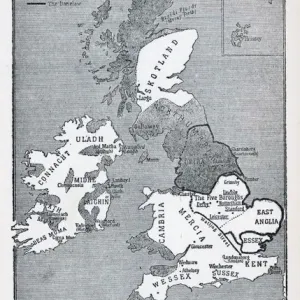
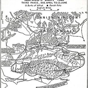
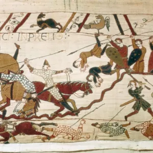
VIKING MAP
A map showing the Viking names for places in Britain
Mary Evans Picture Library makes available wonderful images created for people to enjoy over the centuries
Media ID 610670
© Mary Evans Picture Library 2015 - https://copyrighthub.org/s0/hub1/creation/maryevans/MaryEvansPictureID/10118901
Photo Mug
Introducing the Media Storehouse Photo Mug, perfect for adding a touch of history to your daily routine. Featuring an intriguing image of "VIKING MAP" by Mary Evans Picture Library from Mary Evans Prints Online, this mug showcases the Viking names for places in Britain. Each time you take a sip, you'll be transported back in time to the age of the Vikings. The high-quality ceramic mug is microwave and dishwasher safe, ensuring durability and ease of use. Add this unique and captivating mug to your collection and start your day with a fascinating journey through history.
A personalised photo mug blends sentimentality with functionality, making an ideal gift for cherished loved ones, close friends, or valued colleagues. Preview may show both sides of the same mug.
Elevate your coffee or tea experience with our premium white ceramic mug. Its wide, comfortable handle makes drinking easy, and you can rely on it to be both microwave and dishwasher safe. Sold in single units, preview may show both sides of the same mug so you can see how the picture wraps around.
Mug Size is 9.6cm high x 8.1cm diameter (3.8" x 3.2")
These are individually made so all sizes are approximate
FEATURES IN THESE COLLECTIONS
> Maps and Charts
> Early Maps
> Maps and Charts
> Related Images
EDITORS COMMENTS
This fascinating print showcases a historical Viking map of Britain, dating back to around 800 AD. The intricate details and ancient names for various places in Britain provide a glimpse into the rich history and culture of the Vikings who once roamed these lands.
The map not only serves as a geographical guide but also offers insight into the events and significant locations that were important to the Vikings during this time period. Each place name tells a story, shedding light on the influence and presence of these seafaring warriors in Britain centuries ago.
As we study this map, we can imagine the journeys taken by Viking explorers, their conquests, and interactions with local communities. It is a reminder of how interconnected our world has always been, with cultures blending and influencing one another over time.
Mary Evans Picture Library has preserved this valuable piece of history through their prints collection, allowing us to appreciate and learn from the past. This print is not just a decorative piece but a window into an era long gone yet still relevant in understanding our present-day society.
For history enthusiasts or those curious about Viking heritage, this map is sure to spark interest and curiosity about the events that shaped Britain's landscape centuries ago.
MADE IN AUSTRALIA
Safe Shipping with 30 Day Money Back Guarantee
FREE PERSONALISATION*
We are proud to offer a range of customisation features including Personalised Captions, Color Filters and Picture Zoom Tools
SECURE PAYMENTS
We happily accept a wide range of payment options so you can pay for the things you need in the way that is most convenient for you
* Options may vary by product and licensing agreement. Zoomed Pictures can be adjusted in the Cart.