Photo Mug > Universal Images Group (UIG) > Illustrations > Illustrations 1
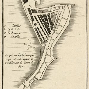
Photo Mug : Map of New Mexico, close-up


![]()
Home Decor from Universal Images Group (UIG)
Map of New Mexico, close-up
Universal Images Group (UIG) manages distribution for many leading specialist agencies worldwide
Media ID 9540233
© Dorling Kindersley/UIG
Digitally Generated Direction Guidance National Border New Mexico State Text Us State Border Western Script
Photo Mug
Bring the beauty of New Mexico's unique landscapes into your daily routine with our Media Storehouse Photo Mugs. Featuring a stunning close-up image of a Map of New Mexico, captured by Dorling Kindersley from Universal Images Group (UIG), these mugs are not just functional but also a delight to behold. Each mug holds your favorite beverage while showcasing the intricate details of the map, making every sip an adventure. Perfect for travel enthusiasts, history buffs, or anyone who appreciates the natural wonders of New Mexico, our Photo Mugs make a thoughtful gift or a treat for yourself. Embrace the charm of the Land of Enchantment with every use.
A personalised photo mug blends sentimentality with functionality, making an ideal gift for cherished loved ones, close friends, or valued colleagues. Preview may show both sides of the same mug.
Elevate your coffee or tea experience with our premium white ceramic mug. Its wide, comfortable handle makes drinking easy, and you can rely on it to be both microwave and dishwasher safe. Sold in single units, preview may show both sides of the same mug so you can see how the picture wraps around.
Mug Size is 9.6cm high x 8.1cm diameter (3.8" x 3.2")
These are individually made so all sizes are approximate
EDITORS COMMENTS
This close-up of a Map of New Mexico by Dorling Kindersley is a true masterpiece in cartography. The vibrant colors and intricate details bring this state's physical geography to life, making it an essential tool for anyone seeking guidance or exploring the wonders of New Mexico. With its square format and Western script, this digitally generated illustration captures the essence of the American Southwest. The map showcases not only the national border but also every US state border that surrounds New Mexico, providing a comprehensive view of its location within the United States. Its accuracy and attention to detail make it an invaluable resource for travelers, researchers, or even those with a deep appreciation for maps as works of art. As we delve into this visually stunning print, we are reminded of how maps can transport us to different places without ever leaving our homes. This particular image from Universal Images Group (UIG) invites us on a journey through time and space as we explore every corner of New Mexico's diverse landscapes - from arid deserts to majestic mountains. Whether displayed in an educational setting or adorning the walls of avid adventurers, this Map of New Mexico serves as both an informative guide and a striking piece of artwork. It encapsulates the beauty and complexity that lies within one state's borders while igniting curiosity about what lies beyond them.
MADE IN AUSTRALIA
Safe Shipping with 30 Day Money Back Guarantee
FREE PERSONALISATION*
We are proud to offer a range of customisation features including Personalised Captions, Color Filters and Picture Zoom Tools
SECURE PAYMENTS
We happily accept a wide range of payment options so you can pay for the things you need in the way that is most convenient for you
* Options may vary by product and licensing agreement. Zoomed Pictures can be adjusted in the Cart.