Photo Mug > Europe > United Kingdom > England > Sussex > Chithurst
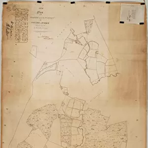
Photo Mug : Chithurst Tithe Map, c. 1840


![]()
Home Decor from West Sussex County Council
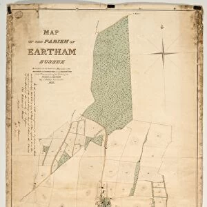
Chithurst Tithe Map, c. 1840
No date, but Tithe Award dated 1840. By Frederick & Henry E. Drayson. 26.6 in. to 1 m. Original map size 83in. × 36in.
Tithe Award Map Collection
West Sussex Record Office Ref No: TD/W31
West Sussex County Council Record Office contains a fascinating history of the county of West Sussex, England
Media ID 7915674
© West Sussex County Council - All Rights Reserved
Photo Mug
Introducing the Media Storehouse Photo Mug featuring a captivating historical image of Chithurst Tithe Map, dating back to around 1840. This intricately detailed map, originally from the West Sussex Record Office, was meticulously captured for you to enjoy in a whole new way. Crafted with premium quality materials, our Photo Mug showcases your chosen image on both sides, allowing you to admire the beauty of the Chithurst Tithe Map from any angle. Whether you're an avid history enthusiast or simply appreciate the intricacies of old maps, this mug is the perfect addition to your daily routine. Embrace the past with every sip from your unique Media Storehouse Photo Mug. Dishwasher safe for added convenience.
A personalised photo mug blends sentimentality with functionality, making an ideal gift for cherished loved ones, close friends, or valued colleagues. Preview may show both sides of the same mug.
Elevate your coffee or tea experience with our premium white ceramic mug. Its wide, comfortable handle makes drinking easy, and you can rely on it to be both microwave and dishwasher safe. Sold in single units, preview may show both sides of the same mug so you can see how the picture wraps around.
Mug Size is 9.6cm high x 8.1cm diameter (3.8" x 3.2")
These are individually made so all sizes are approximate
FEATURES IN THESE COLLECTIONS
> Europe
> United Kingdom
> England
> Sussex
> Chithurst
> Europe
> United Kingdom
> England
> Sussex
> Related Images
> Europe
> United Kingdom
> England
> West Sussex
> Related Images
> Maps and Charts
> Early Maps
> Maps and Charts
> Related Images
> West Sussex County Council
> West Sussex Record Office
> Tithe Award Maps, 1808-1859
EDITORS COMMENTS
This print showcases the Chithurst Tithe Map, a remarkable piece of historical mapping dating back to the 1840s. Created by Frederick and Henry E. Drayson, this map provides a fascinating glimpse into the past and offers valuable insights into land ownership and usage during that era. Measuring an impressive 83 inches by 36 inches in its original size, this meticulously detailed map is now preserved within the Tithe Award Map Collection at West Sussex Record Office. Its significance lies not only in its age but also in its ability to shed light on the social and economic landscape of Chithurst during the mid-19th century. The Chithurst Tithe Map serves as a testament to meticulous craftsmanship and attention to detail. Every inch of this map has been carefully rendered, allowing viewers to explore fields, farms, roads, and boundaries with great precision. It provides historians, researchers, and enthusiasts alike with invaluable information about land divisions and property owners from over 180 years ago. As we admire this stunning print today, it's important to note that it should not be used for commercial purposes or associated with any particular company. Instead, let us appreciate it as a window into history—a visual representation of Chithurst's past that connects us with those who once walked these lands centuries ago.
MADE IN AUSTRALIA
Safe Shipping with 30 Day Money Back Guarantee
FREE PERSONALISATION*
We are proud to offer a range of customisation features including Personalised Captions, Color Filters and Picture Zoom Tools
SECURE PAYMENTS
We happily accept a wide range of payment options so you can pay for the things you need in the way that is most convenient for you
* Options may vary by product and licensing agreement. Zoomed Pictures can be adjusted in the Cart.