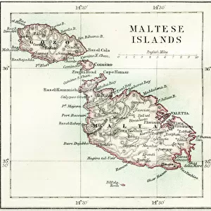
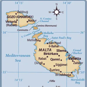
Photographic Print > Europe > Malta > Maps
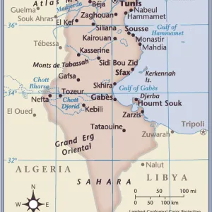
Photographic Print : A 19Th Century Map Of Africa Propria And Numidia


![]()
Photo Prints from Design Pics
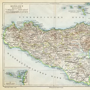
A 19Th Century Map Of Africa Propria And Numidia
Design Pics offers Distinctively Different Imagery representing over 1,500 contributors
Media ID 18188514
© Ken Welsh / Design Pics
Africa African Cartography Drawings Engravings Illustrations Malta North Prints Sicily Tunisia Libia Maltese Nineteenth Numidia Tripolitana Tunisian
10"x8" (25x20cm) Photo Print
Step back in time with our exquisite 19th Century Map of Africa Propria and Numidia print from the Media Storehouse collection, brought to you by Design Pics. This captivating vintage map, created by renowned cartographer Ken Welsh, offers a fascinating glimpse into the historical geography of Africa during the 19th century. With intricate detail and rich, authentic colors, this print is a must-have for history enthusiasts, educators, and anyone seeking to add a touch of nostalgia to their decor. Immerse yourself in the past, and let this stunning piece transport you on a journey through time.
Ideal for framing, Australian made Photo Prints are produced on high-quality 270 gsm lustre photo paper which has a subtle shimmer adding a touch of elegance, designed to enhance their visual appeal.
Our Photo Prints are in a large range of sizes and are printed on Archival Quality Paper for excellent colour reproduction and longevity. They are ideal for framing (our Framed Prints use these) at a reasonable cost. Alternatives include cheaper Poster Prints and higher quality Fine Art Paper, the choice of which is largely dependant on your budget.
Estimated Product Size is 25.4cm x 20.3cm (10" x 8")
These are individually made so all sizes are approximate
Artwork printed orientated as per the preview above, with landscape (horizontal) or portrait (vertical) orientation to match the source image.
FEATURES IN THESE COLLECTIONS
> Africa
> Tunisia
> Related Images
> Europe
> Italy
> Sicily
> Related Images
> Europe
> Malta
> Related Images
> Maps and Charts
> Malta
> Maps and Charts
> Related Images
EDITORS COMMENTS
This print takes us back in time to the 19th century, showcasing a meticulously detailed map of Africa Propria and Numidia. The horizontal composition allows us to explore the vastness of this ancient land, stretching from north to south. The intricate cartography skillfully depicts the geographical features, including rivers, mountains, and coastlines. As our eyes wander across the map, we are transported into a world where exploration was at its peak. This piece is not just a mere illustration; it serves as a historical document that captures Africa's rich heritage. From Tunisia to Libya and Sicily to Malta, every region is carefully labeled with names that evoke curiosity about their significance. The engravings on this print reveal the artistry involved in creating such maps during that era. Each line and curve tells a story of countless hours spent by skilled hands bringing this masterpiece to life. It is evident that Ken Welsh has expertly preserved this piece of history through his meticulous attention to detail. Whether you have an interest in African history or simply appreciate fine art prints, this stunning depiction will surely captivate your imagination. Hang it proudly on your wall as a testament to both Africa's past glory and Ken Welsh's talent for preserving historical treasures through his artwork.
MADE IN AUSTRALIA
Safe Shipping with 30 Day Money Back Guarantee
FREE PERSONALISATION*
We are proud to offer a range of customisation features including Personalised Captions, Color Filters and Picture Zoom Tools
SECURE PAYMENTS
We happily accept a wide range of payment options so you can pay for the things you need in the way that is most convenient for you
* Options may vary by product and licensing agreement. Zoomed Pictures can be adjusted in the Cart.