Photographic Print > Europe > United Kingdom > England > Kent > Stanford
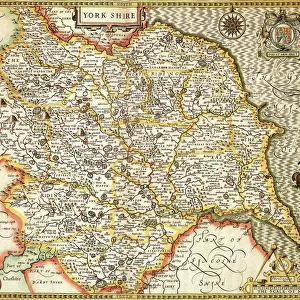
Photographic Print : Map of Britain in 593, printed by Stanfords Geographical Establishment (litho)
")
![]()
Photo Prints from Fine Art Finder
Map of Britain in 593, printed by Stanfords Geographical Establishment (litho)
STC347552 Map of Britain in 593, printed by Stanfords Geographical Establishment (litho) by English School; Private Collection; (add.info.: showing the supremacy of Aethelberht (560-616) King of Kent; ); The Stapleton Collection; English, out of copyright
Media ID 22948168
© The Stapleton Collection / Bridgeman Images
C06th Ethelbert Mapping Power Aethelbert Historical Map
15"x10" (37.5x25cm) Poster
Step back in time with our stunning historical print from the Media Storehouse collection. This exquisite Map of Britain in 593, printed by Stanfords Geographical Establishment (litho) by Bridgeman Images, showcases the fascinating detail of early British cartography. With intricate lines and annotations, this rare find from the English School and a private collection transports you back to a time of exploration and discovery. Add this unique piece to your home or office to ignite conversations and inspire curiosity about the rich history of our islands.
High-quality poster prints are available in a range of sizes and are printed on 270 gsm semi-glossy silk finish poster paper. An affordable option for decorating any space, they are perfect for fixing straight onto walls. To ensure your poster arrives in good condition, we roll and send them in strong mailing tubes.
Our Photo Prints are in a large range of sizes and are printed on Archival Quality Paper for excellent colour reproduction and longevity. They are ideal for framing (our Framed Prints use these) at a reasonable cost. Alternatives include cheaper Poster Prints and higher quality Fine Art Paper, the choice of which is largely dependant on your budget.
Estimated Product Size is 25cm x 37.5cm (9.8" x 14.8")
These are individually made so all sizes are approximate
Artwork printed orientated as per the preview above, with landscape (horizontal) or portrait (vertical) orientation to match the source image.
FEATURES IN THESE COLLECTIONS
> Fine Art Finder
> Artists
> English School
> Fine Art Finder
> Artists
> School English
> Fine Art Finder
> Maps (celestial & Terrestrial)
> Europe
> United Kingdom
> England
> Kent
> Stanford
> Maps and Charts
> Early Maps
> Maps and Charts
> Related Images
EDITORS COMMENTS
This print showcases a historical gem, the "Map of Britain in 593" meticulously printed by Stanfords Geographical Establishment. The lithograph takes us back to an era when Aethelberht, the powerful King of Kent, reigned supreme over the land. With its intricate details and expert craftsmanship, this map offers a glimpse into the past, shedding light on the political landscape of ancient Britain. It reveals not only geographical features but also serves as a testament to Aethelberht's authority as he held sway over his kingdom. The image is part of the esteemed Stapleton Collection and represents an invaluable piece of English history. As we delve into this cartographic masterpiece, we are transported to a time when mapping was both an art form and a means for rulers to assert their power. The engraving technique employed in this print adds depth and texture to every line and contour depicted on the map. It captures our imagination with its portrayal of Britannia under Aethelberht's rule - an imperium that shaped the destiny of these lands. This remarkable photograph from Bridgeman Images allows us to appreciate not only the beauty but also the historical significance encapsulated within this Map of Britain in 593. It stands as a testament to human ingenuity and serves as a reminder that even centuries later, we can still marvel at our ancestors' achievements in charting their world.
MADE IN AUSTRALIA
Safe Shipping with 30 Day Money Back Guarantee
FREE PERSONALISATION*
We are proud to offer a range of customisation features including Personalised Captions, Color Filters and Picture Zoom Tools
SECURE PAYMENTS
We happily accept a wide range of payment options so you can pay for the things you need in the way that is most convenient for you
* Options may vary by product and licensing agreement. Zoomed Pictures can be adjusted in the Cart.