Photographic Print > Fine Art Storehouse > Map
Photographic Print : Political Map of Asia


![]()
Photo Prints from Fine Art Storehouse
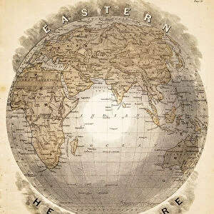
Political Map of Asia
Antique illustration of Political Map of Asia
Unleash your creativity and transform your space into a visual masterpiece!
Nastasic
Media ID 13590323
© This content is subject to copyright
Ancient Greece Ancient History Antiquities Asia Pac Chart Classical Greek Condition Empire Equipment European Culture Greco Roman Wrestling Greece Greek Culture Historical Geopolitical Location Iran Middle East Middle Eastern Culture Navigational Equipment Persian Culture Politics Politics And Government Serbia Styles Classical Style Drawing Art Product
10"x8" (25x20cm) Photo Print
Step back in time with our exquisite Political Map of Asia print from Nastasic, available at Fine Art Storehouse from the Media Storehouse range. This antique illustration transports you back to a bygone era with intricate details of Asian political boundaries as they existed in the past. Add a touch of history and sophistication to your home or office decor with this stunning piece of fine art print. Each print is individually crafted using high-quality materials to ensure vibrant colors and sharp details that will last a lifetime. Order yours today and let this captivating map be a conversation starter in your space.
Ideal for framing, Australian made Photo Prints are produced on high-quality 270 gsm lustre photo paper which has a subtle shimmer adding a touch of elegance, designed to enhance their visual appeal.
Our Photo Prints are in a large range of sizes and are printed on Archival Quality Paper for excellent colour reproduction and longevity. They are ideal for framing (our Framed Prints use these) at a reasonable cost. Alternatives include cheaper Poster Prints and higher quality Fine Art Paper, the choice of which is largely dependant on your budget.
Estimated Product Size is 25.4cm x 20.3cm (10" x 8")
These are individually made so all sizes are approximate
Artwork printed orientated as per the preview above, with landscape (horizontal) orientation to match the source image.
FEATURES IN THESE COLLECTIONS
> Fine Art Storehouse
> The Magical World of Illustration
> Nastasic Images & Illustrations
> Fine Art Storehouse
> Map
> Historical Maps
EDITORS COMMENTS
This print showcases an antique illustration of a Political Map of Asia, taking us on a journey to the past. With its classical Greek style and intricate engravings, this piece offers a glimpse into the historical geopolitical location of Asia, including regions such as Iran, Greece, Serbia, and the Middle East. The map's condition speaks volumes about ancient cultures and their political landscapes. It serves as a testament to the rich history that shaped our world today. The detailed depiction of navigational equipment reminds us of the importance placed on exploration during ancient times. Through this woodcut engraving, we are transported back in time to witness the grandeur of empires like Persia and experience European influences in Asian territories. This artwork not only highlights political boundaries but also sheds light on cultural exchanges between different civilizations. With no people present in this image, it allows us to focus solely on the artistry and craftsmanship behind this exquisite illustration technique. As we delve into each intricately drawn line and carefully etched detail, we gain insight into how cartography played a crucial role in politics and government throughout history. Nastasic's print is more than just an antiquity; it is a window into bygone eras where cultures intertwined through trade routes and greco-roman wrestling was celebrated. This remarkable piece invites viewers to appreciate both its aesthetic beauty and its profound historical significance.
MADE IN AUSTRALIA
Safe Shipping with 30 Day Money Back Guarantee
FREE PERSONALISATION*
We are proud to offer a range of customisation features including Personalised Captions, Color Filters and Picture Zoom Tools
SECURE PAYMENTS
We happily accept a wide range of payment options so you can pay for the things you need in the way that is most convenient for you
* Options may vary by product and licensing agreement. Zoomed Pictures can be adjusted in the Cart.