Photographic Print > Asia > Sri Lanka > Maps
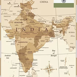
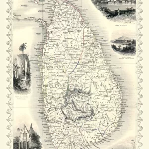
Photographic Print : Antique map of Southern India and Sri Lanka, 19th Century


![]()
Photo Prints from Fine Art Storehouse
Antique map of Southern India and Sri Lanka, 19th Century
Vintage engraving of a Antique map of Southern India and Sri Lanka, 19th Century
Unleash your creativity and transform your space into a visual masterpiece!
duncan1890
Media ID 19684337
© of Duncan P Walker
10"x8" (25x20cm) Photo Print
Step back in time with our exquisite antique map print from the Media Storehouse Fine Art Collection. This stunning vintage engraving, titled "Antique map of Southern India and Sri Lanka, 19th Century" by duncan1890, transports you to a bygone era with its intricate detail and beautiful patina. Meticulously preserved, this antique map offers a captivating glimpse into the history of the Indian subcontinent and Sri Lanka during the 19th century. Add an air of sophistication and historical charm to your home or office with this unique and authentic work of art.
Ideal for framing, Australian made Photo Prints are produced on high-quality 270 gsm lustre photo paper which has a subtle shimmer adding a touch of elegance, designed to enhance their visual appeal.
Our Photo Prints are in a large range of sizes and are printed on Archival Quality Paper for excellent colour reproduction and longevity. They are ideal for framing (our Framed Prints use these) at a reasonable cost. Alternatives include cheaper Poster Prints and higher quality Fine Art Paper, the choice of which is largely dependant on your budget.
Estimated Product Size is 25.4cm x 20.3cm (10" x 8")
These are individually made so all sizes are approximate
Artwork printed orientated as per the preview above, with landscape (horizontal) or portrait (vertical) orientation to match the source image.
FEATURES IN THESE COLLECTIONS
> Fine Art Storehouse
> Map
> Historical Maps
> Asia
> India
> Related Images
> Asia
> Sri Lanka
> Related Images
> Maps and Charts
> India
> Maps and Charts
> Related Images
EDITORS COMMENTS
This print showcases an exquisite antique map of Southern India and Sri Lanka, dating back to the 19th Century. With its intricate details and vintage engraving style, this piece transports us to a bygone era where cartography was both an art form and a scientific endeavor. The map's delicate lines trace the contours of these enchanting lands, revealing their geographical features in stunning accuracy. As we delve into this historical artifact, our eyes are drawn to the Bay of Bengal, which takes center stage on the map. Its vast expanse shimmers with elegance as if inviting us to explore its hidden treasures. From bustling ports to serene coastal towns, one can almost imagine the vibrant trade routes that once thrived along these shores. The artist behind this remarkable creation is Duncan1890, whose attention to detail and passion for preserving history shines through every stroke of his work. Through this print from Fine Art Storehouse, we have the privilege of bringing home a piece of antiquity that not only adds sophistication but also sparks curiosity about our rich cultural heritage. Whether displayed in a study or adorning a living room wall, this antique map serves as a timeless reminder of our connection to the past while igniting wanderlust for those who yearn for adventure beyond borders. Let it transport you on an imaginary voyage through time as you marvel at its beauty and contemplate the stories it holds within its carefully etched lines.
MADE IN AUSTRALIA
Safe Shipping with 30 Day Money Back Guarantee
FREE PERSONALISATION*
We are proud to offer a range of customisation features including Personalised Captions, Color Filters and Picture Zoom Tools
SECURE PAYMENTS
We happily accept a wide range of payment options so you can pay for the things you need in the way that is most convenient for you
* Options may vary by product and licensing agreement. Zoomed Pictures can be adjusted in the Cart.