Photographic Print > Fine Art Storehouse > Map
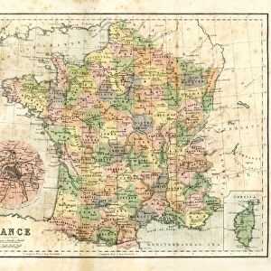
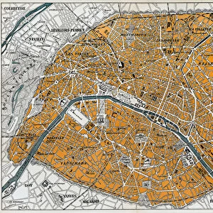
Photographic Print : Fortifications of Paris Map Engraving


![]()
Photo Prints from Fine Art Storehouse
Fortifications of Paris Map Engraving
Engraved illustrations of the Fortifications of Paris from Iconographic Encyclopedia of Science, Literature and Art, Published in 1851. Copyright has expired on this artwork. Digitally restored
Unleash your creativity and transform your space into a visual masterpiece!
bauhaus1000
Media ID 13666953
© Craig McCausland
1850 1859 Chart Diagram Drypoint Fort French Culture Image Created 1850 1859 Paris France Plan Protection Security World Map Drawing Art Product Image Created 19th Century
10"x8" (25x20cm) Photo Print
Step back in time with our exquisite Fortifications of Paris Map Engraving from the Media Storehouse Fine Art collection. This breathtaking piece, created by bauhaus1000, is an engraved illustration taken from the Iconographic Encyclopedia of Science, Literature and Art, published in 1851. With meticulous detail and historical significance, this digitally restored artwork showcases the impressive fortifications of Paris during a bygone era. Elevate your home or office decor with this stunning work of art, now available in our Media Storehouse Fine Art Prints collection.
Ideal for framing, Australian made Photo Prints are produced on high-quality 270 gsm lustre photo paper which has a subtle shimmer adding a touch of elegance, designed to enhance their visual appeal.
Our Photo Prints are in a large range of sizes and are printed on Archival Quality Paper for excellent colour reproduction and longevity. They are ideal for framing (our Framed Prints use these) at a reasonable cost. Alternatives include cheaper Poster Prints and higher quality Fine Art Paper, the choice of which is largely dependant on your budget.
Estimated Product Size is 25.4cm x 20.3cm (10" x 8")
These are individually made so all sizes are approximate
Artwork printed orientated as per the preview above, with landscape (horizontal) or portrait (vertical) orientation to match the source image.
FEATURES IN THESE COLLECTIONS
> Fine Art Storehouse
> Map
> Historical Maps
EDITORS COMMENTS
This print showcases a meticulously engraved illustration of the Fortifications of Paris, taken from the Iconographic Encyclopedia of Science, Literature and Art published in 1851. With its copyright expired, this artwork has been digitally restored to preserve its historical significance. The image transports us back to the 19th century, immersing us in the intricate details of this drypoint engraving. It beautifully captures the essence of cartography and travel during that era, offering a glimpse into French culture and history. As we explore this enchanting piece, we are drawn to the fortifications surrounding Paris - an impressive display of protection and security for one of Europe's most iconic capital cities. The map serves as both a scientific diagram and an artistic representation, showcasing how art intertwines with physical geography. With no people present in this horizontal composition, our focus is solely on the craftsmanship exhibited by bauhaus1000 through their restoration work. This illustration truly exemplifies the artistry prevalent during the mid-19th century. Whether you have an affinity for vintage maps or simply appreciate fine art products that transcend time, this print is sure to captivate your imagination. Let it transport you to a bygone era while celebrating both French heritage and human ingenuity.
MADE IN AUSTRALIA
Safe Shipping with 30 Day Money Back Guarantee
FREE PERSONALISATION*
We are proud to offer a range of customisation features including Personalised Captions, Color Filters and Picture Zoom Tools
SECURE PAYMENTS
We happily accept a wide range of payment options so you can pay for the things you need in the way that is most convenient for you
* Options may vary by product and licensing agreement. Zoomed Pictures can be adjusted in the Cart.