Photographic Print > Asia > India > Maps
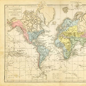
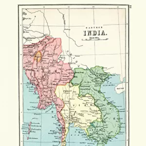
Photographic Print : Historical map of East India, lithograph, published in 1897


![]()
Photo Prints from Fine Art Storehouse
Historical map of East India, lithograph, published in 1897
Historical map of East India. Lithograph, published in 1897
Unleash your creativity and transform your space into a visual masterpiece!
ZU_09
Media ID 18292201
10"x8" (25x20cm) Photo Print
Step back in time with our exquisite Historical Map of East India print from the Media Storehouse Fine Art Collection. This beautiful lithograph, published in 1897, offers a captivating glimpse into the past, showcasing intricate details of the East Indian territories during that era. With its rich historical significance, this stunning piece is a must-have for history enthusiasts, cartographers, and anyone seeking to add a touch of antiquity to their decor. Printed on premium quality paper, this piece is not only a work of art but also a testament to the fascinating history of the East Indies.
Ideal for framing, Australian made Photo Prints are produced on high-quality 270 gsm lustre photo paper which has a subtle shimmer adding a touch of elegance, designed to enhance their visual appeal.
Our Photo Prints are in a large range of sizes and are printed on Archival Quality Paper for excellent colour reproduction and longevity. They are ideal for framing (our Framed Prints use these) at a reasonable cost. Alternatives include cheaper Poster Prints and higher quality Fine Art Paper, the choice of which is largely dependant on your budget.
Estimated Product Size is 20.3cm x 25.4cm (8" x 10")
These are individually made so all sizes are approximate
Artwork printed orientated as per the preview above, with portrait (vertical) orientation to match the source image.
FEATURES IN THESE COLLECTIONS
> Fine Art Storehouse
> Map
> Historical Maps
> Asia
> India
> Related Images
> Maps and Charts
> Early Maps
> Maps and Charts
> India
> Maps and Charts
> Related Images
EDITORS COMMENTS
This lithograph, titled "Historical map of East India" takes us on a mesmerizing journey back in time to the year 1897. Created by the talented artist ZU_09, this intricate print showcases an incredibly detailed representation of the historical region known as East India. The map itself is a true testament to both artistry and cartography, with its delicate lines and exquisite shading bringing each element to life. From sprawling coastlines adorned with elegant ships sailing through vast oceans, to lush forests teeming with wildlife and majestic mountains piercing the sky, every inch of this artwork tells a story. As we explore this historical masterpiece further, we are transported into an era where colonial powers vied for control over these lands. The map highlights significant cities and trading posts that were once bustling hubs of commerce and cultural exchange. It offers glimpses into ancient civilizations that thrived along riverbanks and reveals long-forgotten kingdoms that shaped the course of history. Beyond its aesthetic appeal, this lithograph serves as a valuable educational tool for historians and enthusiasts alike. Its meticulous attention to detail provides invaluable insights into the geography, politics, and societal structures prevalent during that period. Whether displayed in a classroom or cherished within one's personal collection, this remarkable print invites us to delve deeper into our past while marveling at the artistic brilliance captured by ZU_09.
MADE IN AUSTRALIA
Safe Shipping with 30 Day Money Back Guarantee
FREE PERSONALISATION*
We are proud to offer a range of customisation features including Personalised Captions, Color Filters and Picture Zoom Tools
SECURE PAYMENTS
We happily accept a wide range of payment options so you can pay for the things you need in the way that is most convenient for you
* Options may vary by product and licensing agreement. Zoomed Pictures can be adjusted in the Cart.