Photographic Print > North America > United States of America > Kansas > Kansas City
Photographic Print : Kansas City Kansas US City Street Map


![]()
Photo Prints from Fine Art Storehouse
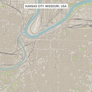
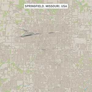
Kansas City Kansas US City Street Map
Vector Illustration of a City Street Map of Kansas City, Kansas, USA. Scale 1:60, 000.
All source data is in the public domain.
U.S. Geological Survey, US Topo
Used Layers:
USGS The National Map: National Hydrography Dataset (NHD)
USGS The National Map: National Transportation Dataset (NTD)
Unleash your creativity and transform your space into a visual masterpiece!
Frank Ramspott
Media ID 15215788
© Frank Ramspott, all rights reserved
Aerial View City Map Computer Graphic Directly Above Downtown District Gray Kansas Road Map Text Digitally Generated Image Green Color Kansas City White Color
10"x8" (25x20cm) Photo Print
Discover the charm of Kansas City, Kansas, with this stunning city street map print from Media Storehouse's Fine Art Storehouse collection. Created by Frank Ramspott, this vector illustration offers a meticulous 1:60,000 scale representation of the city's streets, sourced from public domain data. Add an element of sophistication to your home or office decor with this functional and visually appealing work of art, showcasing the unique character and layout of Kansas City, Kansas. Perfect for both personal use and as a thoughtful gift for someone who cherishes the city's history and culture.
Ideal for framing, Australian made Photo Prints are produced on high-quality 270 gsm lustre photo paper which has a subtle shimmer adding a touch of elegance, designed to enhance their visual appeal.
Our Photo Prints are in a large range of sizes and are printed on Archival Quality Paper for excellent colour reproduction and longevity. They are ideal for framing (our Framed Prints use these) at a reasonable cost. Alternatives include cheaper Poster Prints and higher quality Fine Art Paper, the choice of which is largely dependant on your budget.
Estimated Product Size is 20.3cm x 25.4cm (8" x 10")
These are individually made so all sizes are approximate
Artwork printed orientated as per the preview above, with landscape (horizontal) or portrait (vertical) orientation to match the source image.
FEATURES IN THESE COLLECTIONS
> Fine Art Storehouse
> Map
> Street Maps
> Fine Art Storehouse
> Map
> USA Maps
> Aerial Photography
> Related Images
> Animals
> Insects
> Hemiptera
> Green Scale
> Arts
> Contemporary art
> Digital artwork
> Street art
> Arts
> Landscape paintings
> Waterfall and river artworks
> River artworks
> Arts
> Portraits
> Pop art gallery
> Street art portraits
> Arts
> Street art graffiti
> Digital art
> Digital paintings
> Arts
> Street art graffiti
> Digital art
> Vector illustrations
> Maps and Charts
> Geological Map
> Maps and Charts
> Related Images
> North America
> United States of America
> Kansas
> Kansas City
EDITORS COMMENTS
This print showcases a meticulously detailed city street map of Kansas City, Kansas, USA. With a scale of 1:60,000, every intricate road and landmark is beautifully illustrated in this vector image. The artist behind this masterpiece is Frank Ramspott, who skillfully utilized various layers from the USGS The National Map to create this visually stunning piece. The map encompasses the downtown district of Kansas City and highlights its unique features such as lakes, rivers, and streets. Its design exudes a sense of cartography expertise with digitally generated images that accurately represent the physical geography of the area. The aerial view captured directly above allows viewers to appreciate the city's layout from a bird's-eye perspective. In terms of color scheme, shades of gray dominate most parts while pops of blue and white depict water bodies throughout the map. Green hues symbolize parks or open spaces within the urban landscape. Textual elements are strategically placed to provide additional information without overwhelming the overall composition. It is important to note that all source data used for this artwork is in the public domain courtesy of U. S Geological Survey (USGS) including their National Hydrography Dataset (NHD) and National Transportation Dataset (NTD). This ensures accuracy and authenticity in representing Kansas City's infrastructure. Frank Ramspott has successfully created an exceptional piece that seamlessly combines artistry with geographical precision - making it an ideal addition for any admirer of maps or lovers of fine art alike.
MADE IN AUSTRALIA
Safe Shipping with 30 Day Money Back Guarantee
FREE PERSONALISATION*
We are proud to offer a range of customisation features including Personalised Captions, Color Filters and Picture Zoom Tools
SECURE PAYMENTS
We happily accept a wide range of payment options so you can pay for the things you need in the way that is most convenient for you
* Options may vary by product and licensing agreement. Zoomed Pictures can be adjusted in the Cart.