Photographic Print > North America > Mexico > Maps
Photographic Print : Map Mexico City Delle navigationi et viaggi Ramusio

![]()
Photo Prints from Liszt Collection
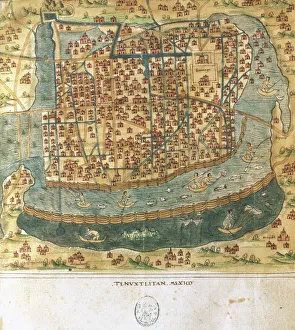
Map Mexico City Delle navigationi et viaggi Ramusio
Map of Mexico City, Delle navigationi et viaggi, Ramusio, Giovanni Battista, 1485-1557, Woodcut, 1606
Liszt Collection of nineteenth-century engravings and images to browse and enjoy
Media ID 18505645
© Liszt Collection
1606 Giovanni Battista Mexico City Ramusio Viaggi
15"x10" (37.5x25cm) Poster
Discover the rich history of Mexico City with our exquisite vintage print from the Media Storehouse range. This stunning woodcut map, titled "Mapa de México Tenochtitlán" from the renowned "Delle navigationi et viaggi" series by Giovanni Battista Ramusio (1485-1557), takes you back in time to the 1606 era. With intricate details and vibrant colors, this beautiful piece of art not only showcases the geography of Mexico City during the early colonial period but also transports you to an era of exploration and discovery. Add a touch of history and sophistication to your home or office décor with this one-of-a-kind, museum-quality print.
High-quality poster prints are available in a range of sizes and are printed on 270 gsm semi-glossy silk finish poster paper. An affordable option for decorating any space, they are perfect for fixing straight onto walls. To ensure your poster arrives in good condition, we roll and send them in strong mailing tubes.
Our Photo Prints are in a large range of sizes and are printed on Archival Quality Paper for excellent colour reproduction and longevity. They are ideal for framing (our Framed Prints use these) at a reasonable cost. Alternatives include cheaper Poster Prints and higher quality Fine Art Paper, the choice of which is largely dependant on your budget.
Estimated Product Size is 25cm x 37.5cm (9.8" x 14.8")
These are individually made so all sizes are approximate
Artwork printed orientated as per the preview above, with landscape (horizontal) or portrait (vertical) orientation to match the source image.
FEATURES IN THESE COLLECTIONS
> Maps and Charts
> Related Images
> North America
> Mexico
> Maps
> North America
> Mexico
> Mexico City
> North America
> Mexico
> Related Images
EDITORS COMMENTS
This print showcases a historic map of Mexico City, taken from the renowned collection "Delle navigationi et viaggi" by Giovanni Battista Ramusio. Created in 1606, this woodcut map offers a fascinating glimpse into the city's past during the late 16th century. The intricate details and artistic craftsmanship of this map are truly remarkable. Every street, building, and landmark is meticulously depicted, providing an invaluable visual record of Mexico City's layout at that time. The viewer can trace their finger along the narrow streets and bustling squares, imagining what life was like in this vibrant metropolis centuries ago. Giovanni Battista Ramusio was a prominent Italian geographer and historian who dedicated his life to documenting various voyages and explorations around the world. His work became highly influential in shaping our understanding of different cultures and civilizations. As we gaze upon this print from the Liszt Collection, we are transported back in time to witness the rich history embedded within Mexico City's foundations. It serves as a testament to human curiosity and exploration while reminding us of our collective heritage.
MADE IN AUSTRALIA
Safe Shipping with 30 Day Money Back Guarantee
FREE PERSONALISATION*
We are proud to offer a range of customisation features including Personalised Captions, Color Filters and Picture Zoom Tools
SECURE PAYMENTS
We happily accept a wide range of payment options so you can pay for the things you need in the way that is most convenient for you
* Options may vary by product and licensing agreement. Zoomed Pictures can be adjusted in the Cart.