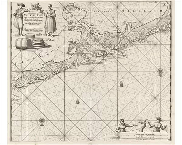
Photographic Print : Sea chart of a large part of the Wadden, Jan Luyken, Johannes van Keulen (I), unknown
![]()

Photo Prints from Liszt Collection
Sea chart of a large part of the Wadden, Jan Luyken, Johannes van Keulen (I), unknown
Sea chart of a large part of the Wadden, Jan Luyken, Johannes van Keulen (I), unknown, 1681 - 1799
Liszt Collection of nineteenth-century engravings and images to browse and enjoy
Media ID 12716365
© Quint Lox Limited
1681 1799 Address Barrels Cartouche Cheese Compass Compasses French Miles Friesland Frisian Groningen Islands Jan Luyken Johannes Van Keulen Mermaid Merman North Roses Sailor Sea Chart Seaman Siren Spanish Stack Cheeses Terschelling Wadden
10"x8" (25x20cm) Photo Print
Experience the historical charm of the past with our exquisite Media Storehouse Photographic Print of "Sea chart of a large part of the Wadden" by Quint Lox from the Liszt Collection. This stunning print showcases a captivating sea chart created by Jan Luyken and Johannes van Keulen between 1681 and 1799. Rich in detail and intrigue, this piece transports you back in time, offering a unique glimpse into the maritime history of the Wadden region. Add this beautiful print to your collection and bring a touch of history into your home or office.
Ideal for framing, Australian made Photo Prints are produced on high-quality 270 gsm lustre photo paper which has a subtle shimmer adding a touch of elegance, designed to enhance their visual appeal.
Our Photo Prints are in a large range of sizes and are printed on Archival Quality Paper for excellent colour reproduction and longevity. They are ideal for framing (our Framed Prints use these) at a reasonable cost. Alternatives include cheaper Poster Prints and higher quality Fine Art Paper, the choice of which is largely dependant on your budget.
Estimated Product Size is 25.4cm x 20.3cm (10" x 8")
These are individually made so all sizes are approximate
Artwork printed orientated as per the preview above, with landscape (horizontal) orientation to match the source image.
EDITORS COMMENTS
This print showcases a remarkable sea chart titled "Sea chart of a large part of the Wadden" created by Jan Luyken and Johannes van Keulen (I) in the late 17th to early 18th century. The map, which spans from Friesland to Groningen and includes notable islands such as Terschelling and Wangerooge, offers an intriguing glimpse into the world of cartography during that era. The intricate details within this artwork are truly mesmerizing. From mermaids and mermen gracefully swimming amidst the waves to a siren enchantingly luring sailors towards unknown territories, every element adds depth and mystery to this historical piece. The presence of compass roses further emphasizes its navigational significance. Notably, one can spot a Frisian woman alongside barrels stacked with cheeses, symbolizing the region's rich cultural heritage. Additionally, key elements like address cartouches provide valuable information for seafarers embarking on their journeys. Quint Lox's expertly captured photograph allows us to appreciate the beauty and intricacy of this antique sea chart. It serves as a reminder of our ancestors' thirst for exploration and their tireless efforts in mapping out our vast world. Whether you are fascinated by geography or simply drawn to historical artifacts, this print is sure to captivate your imagination with its blend of artistry and scientific precision.
MADE IN AUSTRALIA
Safe Shipping with 30 Day Money Back Guarantee
FREE PERSONALISATION*
We are proud to offer a range of customisation features including Personalised Captions, Color Filters and Picture Zoom Tools
SECURE PAYMENTS
We happily accept a wide range of payment options so you can pay for the things you need in the way that is most convenient for you
* Options may vary by product and licensing agreement. Zoomed Pictures can be adjusted in the Cart.

