Photographic Print > Arts > Artists > T > John Tallis
Photographic Print : Western Africa 1851


![]()
Photo Prints from MapSeeker
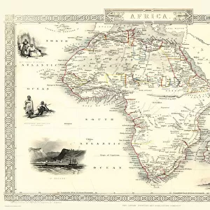
Western Africa 1851
A fine facimile artworked from an antique original map of Western Africa, issued as part of the 1851 edition of John Tallis and Companys " The Illustrated Atlas and Modern History of the World"
Welcome to the Mapseeker Image library and enter an historic gateway to one of the largest on-line collections of Historic Maps, Nostalgic Views, Vista's and Panorama's from a World gone by.
Media ID 20347517
© Mapseeker Publishing Ltd
John Tallis John Tallis Map Tallis Tallis Map West Africa Western Africa
15"x10" (37.5x25cm) Poster
Step back in time with our exquisite reproduction of "Western Africa 1851" by John Tallis and John Rapkin from MapSeeker. This stunning photographic print is a faithful facsimile of an original antique map, taken from the renowned 1851 edition of John Tallis and Company's "The Illustrated Atlas". Each detail is meticulously artworks to preserve the historic charm and intrigue of this iconic cartographic masterpiece. Bring a piece of history into your home or office with this beautiful and authentic reproduction.
High-quality poster prints are available in a range of sizes and are printed on 270 gsm semi-glossy silk finish poster paper. An affordable option for decorating any space, they are perfect for fixing straight onto walls. To ensure your poster arrives in good condition, we roll and send them in strong mailing tubes.
Our Photo Prints are in a large range of sizes and are printed on Archival Quality Paper for excellent colour reproduction and longevity. They are ideal for framing (our Framed Prints use these) at a reasonable cost. Alternatives include cheaper Poster Prints and higher quality Fine Art Paper, the choice of which is largely dependant on your budget.
Estimated Product Size is 37.5cm x 25cm (14.8" x 9.8")
These are individually made so all sizes are approximate
Artwork printed orientated as per the preview above, with landscape (horizontal) or portrait (vertical) orientation to match the source image.
FEATURES IN THESE COLLECTIONS
> MapSeeker
> Maps of Africa and Oceana
> Old Maps Showing the Continent of
> Arts
> Artists
> T
> John Tallis
> Maps and Charts
> Related Images
> Maps and Charts
> World
Western Africa 1851 - A Glimpse into the Rich History of a Vibrant Continent
EDITORS COMMENTS
. This print showcases a fine facsimile artworked from an antique original map of Western Africa, dating back to 1851. Part of John Tallis and Company's renowned "The Illustrated Atlas and Modern History of the World" this exquisite piece offers us a window into the past. As we delve into this old map, we are transported to an era when exploration was at its peak and the world was still being discovered. The intricate details meticulously captured by John Tallis and his collaborator, John Rapkin, bring forth a sense of wonderment about Western Africa's diverse landscapes, cultures, and historical significance. From the vast Sahara Desert in the north to lush rainforests in the south, this map reveals Western Africa's geographical wonders. It highlights major rivers like Niger and Senegal that have shaped civilizations for centuries. Ancient trade routes crisscrossing through bustling cities such as Timbuktu evoke images of vibrant marketplaces filled with exotic goods. Beyond geography, this artwork also serves as a testament to African resilience and cultural heritage. It reminds us that long before colonization or modern borders were established, West Africa thrived with empires like Ghana, Mali, Songhai – centers of artistry and learning that left an indelible mark on history. With each glance at this remarkable print from MapSeeker's collection, we are reminded not only of our shared human
MADE IN AUSTRALIA
Safe Shipping with 30 Day Money Back Guarantee
FREE PERSONALISATION*
We are proud to offer a range of customisation features including Personalised Captions, Color Filters and Picture Zoom Tools
SECURE PAYMENTS
We happily accept a wide range of payment options so you can pay for the things you need in the way that is most convenient for you
* Options may vary by product and licensing agreement. Zoomed Pictures can be adjusted in the Cart.