Photographic Print > Europe > United Kingdom > Scotland > Maps
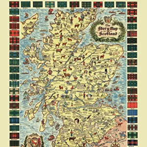
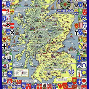
Photographic Print : Map of the Clans and Tartans of Scotland


![]()
Photo Prints from MapSeeker
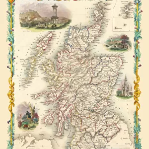
Map of the Clans and Tartans of Scotland
This map of Scotland indicates the general sphere of influence held by the clans and considerable families at the beginning of the 17th century. Some clans and families held small areas of land, and if their names are not on this map, they were not necessarily landless. The areas representing the ancient Principalities of Scotland are indicated on the map. Scotland has a rich and enduring culture steeped in history. One of the most distinctive features, of which are probably that of clanship and the predominantly Highland clans. Highland dress and the tartan is a powerful symbol of the wearerAEs pride in a Scottish ancestry and in Scotland itself. There are few, if any, other forms of national dress which can claim to make such a clear and unequivocal statement, and to be so instantly and widely recognisable
Welcome to the Mapseeker Image library and enter an historic gateway to one of the largest on-line collections of Historic Maps, Nostalgic Views, Vista's and Panorama's from a World gone by.
Media ID 20348040
10"x8" (25x20cm) Photo Print
Introducing the stunning "Map of the Clans and Tartans of Scotland" print from our Media Storehouse collection, brought to you in collaboration with MapSeeker. This exquisite piece of historical artistry transports you back to the early 17th century, offering a captivating glimpse into Scotland's rich tapestry of clans and influential families. With intricate detail and vibrant colors, this map beautifully illustrates the spheres of influence held by various Scottish clans, providing a unique and educational insight into the country's past. Whether you're an avid history enthusiast, a proud Scot, or simply appreciate the beauty of historical cartography, this print is a must-have addition to your home or office. The "Map of the Clans and Tartans of Scotland" print is meticulously reproduced to ensure the highest possible quality, capturing every detail of the original map. Display it proudly on your wall and let the history and heritage of Scotland come alive in your space. Order yours today and join the Media Storehouse family, as we continue to celebrate and share the world's most captivating stories through our extensive range of premium prints.
Ideal for framing, Australian made Photo Prints are produced on high-quality 270 gsm lustre photo paper which has a subtle shimmer adding a touch of elegance, designed to enhance their visual appeal.
Our Photo Prints are in a large range of sizes and are printed on Archival Quality Paper for excellent colour reproduction and longevity. They are ideal for framing (our Framed Prints use these) at a reasonable cost. Alternatives include cheaper Poster Prints and higher quality Fine Art Paper, the choice of which is largely dependant on your budget.
Estimated Product Size is 20.3cm x 25.4cm (8" x 10")
These are individually made so all sizes are approximate
Artwork printed orientated as per the preview above, with portrait (vertical) orientation to match the source image.
FEATURES IN THESE COLLECTIONS
> MapSeeker
> Maps from the British Isles
> Scotland and Counties PORTFOLIO
> Europe
> France
> Canton
> Landes
> Europe
> United Kingdom
> Scotland
> Maps
> Europe
> United Kingdom
> Scotland
> Posters
> Europe
> United Kingdom
> Scotland
> Related Images
> Maps and Charts
> Early Maps
> Maps and Charts
> Related Images
EDITORS COMMENTS
This print showcases the "Map of the Clans and Tartans of Scotland" offering a glimpse into the intricate web of influence held by clans and notable families during the early 17th century. While some clans and families may not be featured on this map, it does not imply their landlessness, as they might have possessed smaller territories. The map also highlights the ancient Principalities of Scotland, providing insight into the historical divisions within this culturally rich nation. Scotland's enduring heritage is deeply rooted in its unique features such as clanship and predominantly Highland clans. Among these distinct characteristics, Highland dress and tartan stand out as powerful symbols representing pride in Scottish ancestry and love for their homeland. With its unmistakable design, tartan has become an iconic representation of Scottish identity. Few other national dresses can rival its ability to make such a clear statement or enjoy such widespread recognition across borders. This print serves as a reminder of Scotland's profound history while celebrating its cultural traditions that continue to resonate with people around the world.
MADE IN AUSTRALIA
Safe Shipping with 30 Day Money Back Guarantee
FREE PERSONALISATION*
We are proud to offer a range of customisation features including Personalised Captions, Color Filters and Picture Zoom Tools
SECURE PAYMENTS
We happily accept a wide range of payment options so you can pay for the things you need in the way that is most convenient for you
* Options may vary by product and licensing agreement. Zoomed Pictures can be adjusted in the Cart.