Photographic Print > Maps and Charts > Early Maps
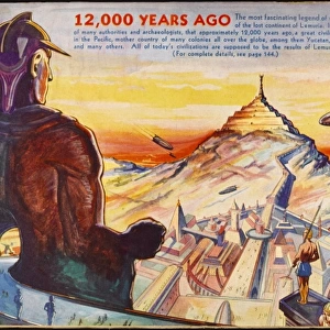
Photographic Print : Lemuria Map


![]()
Photo Prints from Mary Evans Picture Library
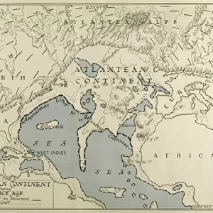
Lemuria Map
A map of Lemuria at its greatest extent
Mary Evans Picture Library makes available wonderful images created for people to enjoy over the centuries
Media ID 581225
© Mary Evans Picture Library 2015 - https://copyrighthub.org/s0/hub1/creation/maryevans/MaryEvansPictureID/10026655
Extent Folk Lore Greatest Mythical Places Lemuria
10"x8" (25x20cm) Photo Print
Discover the mystical world of Lemuria with our stunning photographic print from Mary Evans Picture Library. This captivating image, titled "Lemuria Map," offers a glimpse into the ancient civilization believed to have existed in the Indian Ocean before the rise of the Indian and Indonesian subcontinents. This intricately detailed map, showcasing Lemuria at its greatest extent, is a must-have for any collection dedicated to ancient history, mythology, or geography. Bring the enigmatic allure of Lemuria into your home or office with our high-quality, museum-grade prints, and transport yourself to a time long past.
Ideal for framing, Australian made Photo Prints are produced on high-quality 270 gsm lustre photo paper which has a subtle shimmer adding a touch of elegance, designed to enhance their visual appeal.
Our Photo Prints are in a large range of sizes and are printed on Archival Quality Paper for excellent colour reproduction and longevity. They are ideal for framing (our Framed Prints use these) at a reasonable cost. Alternatives include cheaper Poster Prints and higher quality Fine Art Paper, the choice of which is largely dependant on your budget.
Estimated Product Size is 25.4cm x 20.3cm (10" x 8")
These are individually made so all sizes are approximate
Artwork printed orientated as per the preview above, with landscape (horizontal) or portrait (vertical) orientation to match the source image.
FEATURES IN THESE COLLECTIONS
> Maps and Charts
> Early Maps
> Maps and Charts
> Related Images
EDITORS COMMENTS
This stunning print of the Lemuria Map showcases the mythical and historical significance of this lost continent. Created in 1904, this map depicts Lemuria at its greatest extent, offering a glimpse into the folklore and legends surrounding this mysterious land.
Lemuria is a place shrouded in mystery and intrigue, with tales of advanced civilizations and ancient cultures that once thrived there. The intricate details on this map bring to life the various places and landmarks that are said to have existed on Lemuria.
As you study this map, you can't help but be captivated by the rich history and lore associated with Lemuria. From Mu to its greatest extent, every corner of this mythical land is filled with stories waiting to be discovered.
Mary Evans Picture Library has truly captured the essence of Lemuria through this beautiful print. It serves as a reminder of our fascination with lost civilizations and unexplored territories, sparking our imagination and curiosity about what lies beyond our known world.
Whether you're a history buff or simply intrigued by myths and legends, this Lemuria Map is sure to transport you to a realm where anything is possible. Let yourself get lost in the enchanting world of Lemuria as you explore every inch of this map.
MADE IN AUSTRALIA
Safe Shipping with 30 Day Money Back Guarantee
FREE PERSONALISATION*
We are proud to offer a range of customisation features including Personalised Captions, Color Filters and Picture Zoom Tools
SECURE PAYMENTS
We happily accept a wide range of payment options so you can pay for the things you need in the way that is most convenient for you
* Options may vary by product and licensing agreement. Zoomed Pictures can be adjusted in the Cart.