Photographic Print > Europe > France > Maps
Photographic Print : Map / Europe / France C1000


![]()
Photo Prints from Mary Evans Picture Library
Map / Europe / France C1000
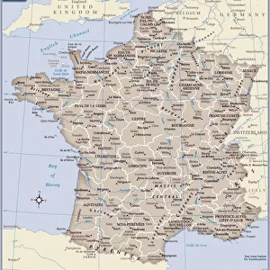
France in feudal times, with the country allotted to various nobles who bore more or less allegiance to the king, whose acquisitions are shown in map lower left
Mary Evans Picture Library makes available wonderful images created for people to enjoy over the centuries
Media ID 594579
© Mary Evans Picture Library 2015 - https://copyrighthub.org/s0/hub1/creation/maryevans/MaryEvansPictureID/10046920
1000 1500 Allegiance Allotted Bore Feudal Lower Maps Nobles Shown Times
10"x8" (25x20cm) Photo Print
Discover the rich history of medieval France with our exquisite selection of photographic prints from the Media Storehouse range, sourced from the esteemed Mary Evans Prints Online. Witness the intricate feudal map of Europe, specifically focusing on France (C1000), meticulously detailed to depict the territories of various nobles, each with their degree of loyalty to the monarch. This captivating print offers a mesmerizing journey into the political landscape of the era, a must-have for history enthusiasts and art collectors alike.
Ideal for framing, Australian made Photo Prints are produced on high-quality 270 gsm lustre photo paper which has a subtle shimmer adding a touch of elegance, designed to enhance their visual appeal.
Our Photo Prints are in a large range of sizes and are printed on Archival Quality Paper for excellent colour reproduction and longevity. They are ideal for framing (our Framed Prints use these) at a reasonable cost. Alternatives include cheaper Poster Prints and higher quality Fine Art Paper, the choice of which is largely dependant on your budget.
Estimated Product Size is 25.4cm x 20.3cm (10" x 8")
These are individually made so all sizes are approximate
Artwork printed orientated as per the preview above, with landscape (horizontal) or portrait (vertical) orientation to match the source image.
FEATURES IN THESE COLLECTIONS
> Europe
> Related Images
> Maps and Charts
> Early Maps
> Maps and Charts
> Related Images
EDITORS COMMENTS
Step back in time with this map print of Feudal France in the year 1000, as depicted in the historical map "France C1000" from Mary Evans Prints Online. This map offers a fascinating glimpse into the complex political landscape of medieval France, where the country was allotted to various nobles who bore more or less allegiance to the king. At the lower left corner of the map, the acquisitions of the king are shown, providing a clear illustration of the monarch's territorial holdings during this period. The intricate details of the map reveal the vast expanse of lands controlled by these noble families, each with their own distinct territories and domains. As you explore this historical map, you'll notice the intricate borders that mark the territories of the various feudal lords, each with their unique symbols and insignia. The map also highlights the major cities and rivers of the time, providing context to the political and geographical landscape of medieval France. This map is a testament to the rich history of France during the feudal period, a time when the country was a patchwork of territories ruled by powerful nobles, each with their own allegiances and loyalties. The intricate details of this map offer a unique perspective into this complex and fascinating era, making it an essential addition to any history or map enthusiast's collection. The "France C1000" map is not only a beautiful work of art, but also an invaluable historical resource, providing insights into the political and geographical landscape of medieval France during a time of great change and transformation. Whether you're a history buff, a map collector, or simply someone with an interest in the Middle Ages, this map is sure to captivate and inspire you.
MADE IN AUSTRALIA
Safe Shipping with 30 Day Money Back Guarantee
FREE PERSONALISATION*
We are proud to offer a range of customisation features including Personalised Captions, Color Filters and Picture Zoom Tools
SECURE PAYMENTS
We happily accept a wide range of payment options so you can pay for the things you need in the way that is most convenient for you
* Options may vary by product and licensing agreement. Zoomed Pictures can be adjusted in the Cart.