Photographic Print > North America > The Bahamas > Maps
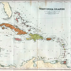
Photographic Print : Nassau, Bahamas - Map of the Island of New Providence


![]()
Photo Prints from Mary Evans Picture Library
Nassau, Bahamas - Map of the Island of New Providence
Nassau, Bahamas - Map of the Island of New Providence. Date: circa 1950s
Mary Evans Picture Library makes available wonderful images created for people to enjoy over the centuries
Media ID 32228252
© Mary Evans / Grenville Collins Postcard Collection
Archipelago Atlantic Bahamas Chart Commonwealth Compass Indies Lucayan Nassau Plan Providence
15"x10" (37.5x25cm) Poster
Discover the charm of Nassau, Bahamas with this vintage map print by Grenville Collins. Dating back to the 1950s, this captivating image invites you to explore the Island of New Providence like never before. With intricate detail and beautiful color, this photographic print from Media Storehouse transports you to the tropical paradise of Nassau. A perfect addition to any home or office, this map print is a unique and thoughtful gift for any travel enthusiast or collector of vintage maps. Bring a piece of the Bahamas into your space and let the adventure begin!
High-quality poster prints are available in a range of sizes and are printed on 270 gsm semi-glossy silk finish poster paper. An affordable option for decorating any space, they are perfect for fixing straight onto walls. To ensure your poster arrives in good condition, we roll and send them in strong mailing tubes.
Our Photo Prints are in a large range of sizes and are printed on Archival Quality Paper for excellent colour reproduction and longevity. They are ideal for framing (our Framed Prints use these) at a reasonable cost. Alternatives include cheaper Poster Prints and higher quality Fine Art Paper, the choice of which is largely dependant on your budget.
Estimated Image Size (if not cropped) is 37.5cm x 24cm (14.8" x 9.4")
Estimated Product Size is 37.5cm x 25cm (14.8" x 9.8")
These are individually made so all sizes are approximate
Artwork printed orientated as per the preview above, with landscape (horizontal) orientation to match the source image.
FEATURES IN THESE COLLECTIONS
> Mary Evans Prints Online
> New Images July 2023
> Maps and Charts
> Related Images
> North America
> The Bahamas
> Maps
> North America
> The Bahamas
> Nassau
> North America
> The Bahamas
> Related Images
EDITORS COMMENTS
Transport yourself back in time to the vibrant and bustling streets of Nassau, Bahamas with this vintage map print of the Island of New Providence. Dating back to the 1950s, this detailed chart captures the essence of a bygone era in this tropical paradise.
The map showcases the layout of Nassau, the capital city of The Bahamas, located on New Providence Island in the Lucayan Archipelago. With its colorful compass rose and intricate street plan, you can almost imagine navigating your way through historic landmarks such as Government House or Fort Charlotte.
As you study this piece, you can't help but feel a sense of nostalgia for a simpler time when life moved at a slower pace and island living was all about relaxation and tranquility. The 1950s were a golden age for tourism in The Bahamas, attracting visitors from around the world who sought sun-kissed beaches and crystal-clear waters.
Whether you have fond memories of visiting Nassau during this era or simply appreciate vintage cartography, this map print is sure to evoke feelings of wanderlust and adventure. Hang it on your wall as a reminder of past travels or dream about future journeys to explore this enchanting corner of the West Indies.
MADE IN AUSTRALIA
Safe Shipping with 30 Day Money Back Guarantee
FREE PERSONALISATION*
We are proud to offer a range of customisation features including Personalised Captions, Color Filters and Picture Zoom Tools
SECURE PAYMENTS
We happily accept a wide range of payment options so you can pay for the things you need in the way that is most convenient for you
* Options may vary by product and licensing agreement. Zoomed Pictures can be adjusted in the Cart.