Photographic Print > Europe > France > Canton > Bas Rhin
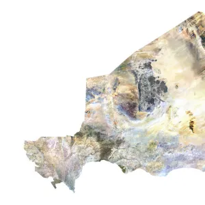
Photographic Print : Niger, Satellite Image


![]()
Photo Prints from Universal Images Group (UIG)
Niger, Satellite Image
Satellite view of Niger. This image was compiled from data acquired by LANDSAT satellite
Universal Images Group (UIG) manages distribution for many leading specialist agencies worldwide
Media ID 9618211
© Planet Observer
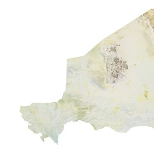
Alsace Bas Rhin Geographical Border Relief Map Satellite View
10"x8" (25x20cm) Photo Print
Discover the unique beauty of Niger from a new perspective with our Media Storehouse Photographic Prints. This stunning satellite image from Universal Images Group (UIG) captures the expansive landscapes of Niger as seen from the LANDSAT satellite. Explore intriguing patterns and natural features that can only be appreciated from above. Bring this captivating view into your home or office as a conversation starter or a source of inspiration. Order your Media Storehouse Photographic Print of Niger today and expand your horizons.
Ideal for framing, Australian made Photo Prints are produced on high-quality 270 gsm lustre photo paper which has a subtle shimmer adding a touch of elegance, designed to enhance their visual appeal.
Our Photo Prints are in a large range of sizes and are printed on Archival Quality Paper for excellent colour reproduction and longevity. They are ideal for framing (our Framed Prints use these) at a reasonable cost. Alternatives include cheaper Poster Prints and higher quality Fine Art Paper, the choice of which is largely dependant on your budget.
Estimated Image Size (if not cropped) is 25.4cm x 18.3cm (10" x 7.2")
Estimated Product Size is 25.4cm x 20.3cm (10" x 8")
These are individually made so all sizes are approximate
Artwork printed orientated as per the preview above, with landscape (horizontal) orientation to match the source image.
FEATURES IN THESE COLLECTIONS
> Africa
> Niger
> Related Images
> Animals
> Mammals
> Soricidae
> Niger
> Europe
> France
> Canton
> Bas Rhin
> Europe
> France
> Canton
> Rhin
> Maps and Charts
> Related Images
> Universal Images Group (UIG)
> Universal Images Group
> Satellite and Aerial
> Planet Observer 6
EDITORS COMMENTS
This stunning print captures the breathtaking beauty of Niger from a unique perspective - a satellite view. Acquired by the LANDSAT satellite, this image showcases the mesmerizing topography and physical geography of this African nation. The vibrant colors and intricate details bring to life the diverse landscapes that make up Niger's vast territory. From soaring mountains to expansive deserts, every inch of this photograph tells a story of resilience and natural wonders. The relief map reveals the undulating contours of Niger's terrain, while geographical borders mark its boundaries with precision. With no people in sight, one can truly appreciate the untouched majesty of this land. As we gaze upon this image, it is impossible not to be drawn into its allure. The vertical composition allows us to immerse ourselves in every corner, exploring each distinct region with curiosity and awe. Whether you are an avid cartographer or simply an admirer of nature's grandeur, this print offers a glimpse into Niger's hidden treasures. Universal Images Group (UIG) has once again captured an extraordinary moment in time through their lens. This photograph serves as a reminder that there is so much more to discover beyond our immediate surroundings - a world full of wonderment waiting for us to explore. Let your imagination soar as you delve into the depths of Niger through this remarkable satellite view print.
MADE IN AUSTRALIA
Safe Shipping with 30 Day Money Back Guarantee
FREE PERSONALISATION*
We are proud to offer a range of customisation features including Personalised Captions, Color Filters and Picture Zoom Tools
SECURE PAYMENTS
We happily accept a wide range of payment options so you can pay for the things you need in the way that is most convenient for you
* Options may vary by product and licensing agreement. Zoomed Pictures can be adjusted in the Cart.