Poster Print > Arts > Artists > W > Frederick de Wit
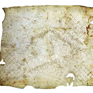
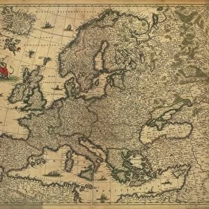
Poster Print : Pascaart van de Noort Zee verthoonende in zich alle de Custen en havens daer rontom gelegen. 1654 (print, paper)
")


![]()
Poster Prints From Fine Art Finder
Pascaart van de Noort Zee verthoonende in zich alle de Custen en havens daer rontom gelegen. 1654 (print, paper)
7340057 Pascaart van de Noort Zee verthoonende in zich alle de Custen en havens daer rontom gelegen. 1654 (print, paper) by Wit, Frederick de (1630-1706); 50.5x58.5 cm; National Maritime Museum, London, UK; (add.info.: Creator: Frederik de Wit
Bound sheet. Hand col. engr. Scale: [ca. 1: (bar)]. Cartographic Note: North at 90 degrees. Graduated for latitude only. Bar scales in Dutch miles, Spanish miles and English and French miles. Additional Places: North Sea. Contents Note: Cartouche decoration includes navigational instruments - cross staff and sphere.
In an atlas of twelve charts, seven by Frederik de Wit and five by Theunis Jacobz.); © National Maritime Museum, Greenwich, London
Media ID 38412530
© © National Maritime Museum, Greenwich, London / Bridgeman Images
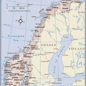
North Sea Norway Norway Norwegian Norwegian Norwegians Dutch Netherlands Hollander Hollanders Netherland Netherlands Holland Dutch Scotland Scotish The Netherland
A3 (42 x 29.7cm) Poster Print
Chart the course of history with our Media Storehouse range of Poster Prints! This stunning reproduction from Bridgeman Images features 'Pascaart van de Noort Zee verthoonende in zich alle de Custen en havens daer rontom gelegen. 1654' by Frederick de Wit, a rare and fascinating map that showcases the Dutch cartographer's mastery of maritime artistry. A must-have for history buffs and ocean enthusiasts alike!
Premium quality poster prints are printed on luxurious semi-gloss satin 270 gsm paper. Our meticulously crafted poster prints offer an affordable option for decorating any space, making them ideal for living rooms, bedrooms, offices and beyond. To ensure your poster arrives in good condition, we roll and send them in strong mailing tubes.
Poster prints are budget friendly enlarged prints in standard poster paper sizes (A0, A1, A2, A3 etc). Whilst poster paper is sometimes thinner and less durable than our other paper types, they are still ok for framing and should last many years. Our Archival Quality Photo Prints and Fine Art Paper Prints are printed on higher quality paper and the choice of which largely depends on your budget.
Estimated Product Size is 42.6cm x 30.6cm (16.8" x 12")
These are individually made so all sizes are approximate
Artwork printed orientated as per the preview above, with landscape (horizontal) orientation to match the source image.
FEATURES IN THESE COLLECTIONS
> Arts
> Artists
> W
> Frederick de Wit
> Europe
> Netherlands
> Maps
> Europe
> Netherlands
> Posters
> Europe
> Netherlands
> Related Images
> Europe
> Norway
> Related Images
> Europe
> Republic of Ireland
> Maps
EDITORS COMMENTS
This stunning print, "Pascaart van de Noort Zee verthoonende in zich alle de Custen en havens daer rontom gelegen" by Frederick de Wit, is a true masterpiece of 17th-century cartography. The intricate details and vibrant colors bring to life the coastlines and harbors surrounding the North Sea, providing a glimpse into the maritime world of centuries past.
Measuring at 50.5x58.5 cm, this print is part of an atlas containing twelve charts, seven by De Wit himself and five by Theunis Jacobz. The meticulous craftsmanship is evident in every aspect of this piece, from the carefully drawn navigational instruments in the cartouche decoration to the precise bar scales indicating Dutch miles, Spanish miles, English miles, and French miles.
The map's orientation with north at 90 degrees allows viewers to easily navigate through the various regions depicted on it. From Scotland to Norway to the Netherlands, each area is beautifully rendered with attention to detail that showcases De Wit's skill as a cartographer.
As you gaze upon this print from the National Maritime Museum in London, you can't help but be transported back in time to an era when exploration and discovery were paramount. It serves as a reminder of our rich maritime history and the importance of maps in shaping our understanding of the world around us.
MADE IN AUSTRALIA
Safe Shipping with 30 Day Money Back Guarantee
FREE PERSONALISATION*
We are proud to offer a range of customisation features including Personalised Captions, Color Filters and Picture Zoom Tools
SECURE PAYMENTS
We happily accept a wide range of payment options so you can pay for the things you need in the way that is most convenient for you
* Options may vary by product and licensing agreement. Zoomed Pictures can be adjusted in the Basket.