Poster Print > Europe > United Kingdom > England > London > Boroughs > City of London
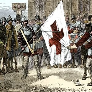
Poster Print : Geographical distribution of the Great Plague of London, 1665-1666 (litho)
")


![]()
Poster Prints from Fine Art Finder
Geographical distribution of the Great Plague of London, 1665-1666 (litho)
7201755 Geographical distribution of the Great Plague of London, 1665-1666 (litho) by English School, (20th century); Private Collection; (add.info.: Geographical distribution of the Great Plague of London, 1665-1666. Illustration from The Great Plague in London in 1665, by Walter George Bell (The Bodley Head, London, 1924). Credit: Walter G Bell.); © Look and Learn
Media ID 24700778
© Look and Learn / Bridgeman Images
Ailments Bubonic Plague City Map City Plan Contagion Disease Epidemia Epidemic General Map Great Plague Illness Infected Infectious Infirmity London Nw Majestic Rivers Maladies Malady Mountain River Pandemic Plague Plague Victim Plagues River Course River System Sexually Transmitted Disease Sick Sickness Statistic Statistical Analysis Statistics Stds Street Plan The City Of London Tributaries Venereal Disease Asclepius Asklepieion Asklepios Deaths Medical Science Mortality Passed Away
A1 (84.1 x 59.4cm) Poster Print
Discover the historical depth of the Great Plague of London with our captivating poster prints from Media Storehouse. This intriguing piece, titled "Geographical distribution of the Great Plague of London, 1665-1666" by the English School, showcases an enlightening lithograph from Bridgeman Images. This 20th-century reproduction, sourced from a private collection, offers a unique perspective on the devastating impact of the plague on London during that era. Bring a piece of history into your home or office with this beautifully detailed and informative poster print.
Premium quality poster prints are printed on luxurious glossy or matte 270 gsm paper. Our meticulously crafted poster prints offer an affordable option for decorating any space, making them ideal for living rooms, bedrooms, offices and beyond. To ensure your poster arrives in good condition, we roll and send them in strong mailing tubes.
Poster prints are budget friendly enlarged prints in standard poster paper sizes (A0, A1, A2, A3 etc). Whilst poster paper is sometimes thinner and less durable than our other paper types, they are still ok for framing and should last many years. Our Archival Quality Photo Prints and Fine Art Paper Prints are printed on higher quality paper and the choice of which largely depends on your budget.
Estimated Image Size (if not cropped) is 84.6cm x 49.1cm (33.3" x 19.3")
Estimated Product Size is 84.6cm x 59.6cm (33.3" x 23.5")
These are individually made so all sizes are approximate
Artwork printed orientated as per the preview above, with landscape (horizontal) orientation to match the source image.
FEATURES IN THESE COLLECTIONS
> Fine Art Finder
> Artists
> English School
> Fine Art Finder
> Schools
> English School
> Arts
> Artists
> W
> George White
> Europe
> United Kingdom
> England
> London
> Boroughs
> City of London
> Europe
> United Kingdom
> England
> London
> River Thames
> Europe
> United Kingdom
> England
> Maps
> Europe
> United Kingdom
> England
> Rivers
> Europe
> United Kingdom
> Maps
> Maps and Charts
> Early Maps
> Maps and Charts
> Related Images
EDITORS COMMENTS
This lithograph print showcases the geographical distribution of the Great Plague of London, which ravaged the city in 1665-1666. Created by an unknown English artist in the 20th century, this artwork is a reproduction from Walter George Bell's book "The Great Plague in London in 1665". The detailed illustration provides a visual representation of how the plague spread throughout different areas of London during that devastating time. The map depicts England and its surrounding regions, highlighting various cities and towns affected by the epidemic. It serves as a historical record, shedding light on one of Europe's most infamous outbreaks. The Great Plague was an epidemic that caused widespread illness and death, leaving communities devastated and forever changing society. Through this lithograph print, we can gain insight into the impact of infectious diseases on past civilizations while appreciating both its historical significance and artistic value. It reminds us of our vulnerability to pandemics throughout history and emphasizes the importance of medical advancements in combating such crises. Displayed within private collections today, this artwork allows us to reflect upon humanity's resilience in times of adversity while acknowledging our continued efforts to understand and combat diseases. As we observe this piece from Fine Art Finder by Bridgeman Images, it serves as a reminder to appreciate modern medicine's progress while remaining vigilant against future health challenges.
MADE IN AUSTRALIA
Safe Shipping with 30 Day Money Back Guarantee
FREE PERSONALISATION*
We are proud to offer a range of customisation features including Personalised Captions, Color Filters and Picture Zoom Tools
SECURE PAYMENTS
We happily accept a wide range of payment options so you can pay for the things you need in the way that is most convenient for you
* Options may vary by product and licensing agreement. Zoomed Pictures can be adjusted in the Cart.