Poster Print > Europe > United Kingdom > Wales > Pembrokeshire > Milford Haven
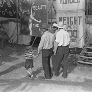
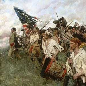
Poster Print : Map drawn by Thomas Jefferson of Milford Haven on Chesapeake Bay and vicinity, showing camp on Gwynns Island and enemy fortifications, June or July 1776


![]()
Poster Prints from Granger
Map drawn by Thomas Jefferson of Milford Haven on Chesapeake Bay and vicinity, showing camp on Gwynns Island and enemy fortifications, June or July 1776
CHESAPEAKE BAY, 1776.
Map drawn by Thomas Jefferson of Milford Haven on Chesapeake Bay and vicinity, showing camp on Gwynns Island and enemy fortifications, June or July 1776
Granger holds millions of images spanning more than 25,000 years of world history, from before the Stone Age to the dawn of the Space Age
Media ID 10408406
1776 American Revolution British Chesapeake Bay Diagram Enemy Fort Handwriting Island Jefferson July Plan United States Milford Haven Southeast
A4 (29.7 x 21cm) Poster Print
"Step back in time with our authentic and captivating Map Print from the Media Storehouse collection. This exquisite reproduction, sourced from Granger Art on Demand, showcases a rare and historically significant map drawn by Thomas Jefferson in 1776. The map depicts Milford Haven on Chesapeake Bay and its vicinity, including Jefferson's own camp on Gwynns Island and enemy fortifications. A fascinating glimpse into the past, this vintage map print adds character and historical depth to any room in your home or office."
Premium quality poster prints are printed on luxurious semi-gloss satin 270 gsm paper. Our meticulously crafted poster prints offer an affordable option for decorating any space, making them ideal for living rooms, bedrooms, offices and beyond. To ensure your poster arrives in good condition, we roll and send them in strong mailing tubes.
Poster prints are budget friendly enlarged prints in standard poster paper sizes (A0, A1, A2, A3 etc). Whilst poster paper is sometimes thinner and less durable than our other paper types, they are still ok for framing and should last many years. Our Archival Quality Photo Prints and Fine Art Paper Prints are printed on higher quality paper and the choice of which largely depends on your budget.
Estimated Image Size (if not cropped) is 30.3cm x 19.5cm (11.9" x 7.7")
Estimated Product Size is 30.3cm x 21.6cm (11.9" x 8.5")
These are individually made so all sizes are approximate
Artwork printed orientated as per the preview above, with landscape (horizontal) orientation to match the source image.
FEATURES IN THESE COLLECTIONS
> Granger Art on Demand
> American Revolution
> Granger Art on Demand
> Plans and Diagrams
> Arts
> Artists
> J
> Thomas Jefferson
> Europe
> United Kingdom
> Wales
> Pembrokeshire
> Milford Haven
> Maps and Charts
> Related Images
EDITORS COMMENTS
This print showcases a historically significant map drawn by none other than Thomas Jefferson himself. Created in June or July of 1776, during the American Revolution, this meticulously detailed map depicts Milford Haven on Chesapeake Bay and its surrounding areas. The focal point of the map is Gwynns Island, where a camp was established at that time. Jefferson's keen eye for detail is evident as he accurately portrays both the camp on Gwynns Island and the enemy fortifications present during this period. This invaluable visual representation offers a glimpse into the strategic planning and military operations undertaken by both sides during this pivotal moment in American history. The handwriting on the map bears witness to Jefferson's personal touch, further emphasizing his involvement in creating this remarkable piece. As one of America's founding fathers and later serving as its third president, Jefferson's contributions to shaping the United States cannot be overstated. This print from Granger Art on Demand allows us to appreciate not only Jefferson's artistic abilities but also his role as an astute observer and strategist during a crucial juncture in our nation's journey towards independence. It serves as a testament to his multifaceted talents and enduring legacy within American history.
MADE IN AUSTRALIA
Safe Shipping with 30 Day Money Back Guarantee
FREE PERSONALISATION*
We are proud to offer a range of customisation features including Personalised Captions, Color Filters and Picture Zoom Tools
SECURE PAYMENTS
We happily accept a wide range of payment options so you can pay for the things you need in the way that is most convenient for you
* Options may vary by product and licensing agreement. Zoomed Pictures can be adjusted in the Cart.