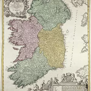
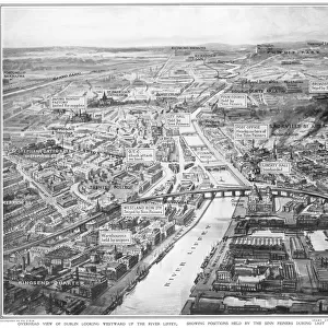
Poster Print : MAP: NORTHERN IRELAND. Map of the Ulster Province of Northern Ireland. Drawing, c1885


![]()
Poster Prints from Granger
MAP: NORTHERN IRELAND. Map of the Ulster Province of Northern Ireland. Drawing, c1885
MAP: NORTHERN IRELAND.
Map of the Ulster Province of Northern Ireland. Drawing, c1885
Granger holds millions of images spanning more than 25,000 years of world history, from before the Stone Age to the dawn of the Space Age
Media ID 13641780
1880s 1885 Antrim Belfast Coat Of Arms County Down Hand Irish Londonderry Province Armagh Cavan Donegal Fermanagh Monaghan Northern Ireland Northern Irish Tyrone Ulster
A4 (29.7 x 21cm) Poster Print
Discover the rich history of Northern Ireland with our exquisite poster print from The Granger Collection. Dated back to 1885, this captivating map of the Ulster Province showcases intricate details of the region during that era. The vintage drawing style adds a touch of timeless charm to any space. Bring history into your home or office with this beautiful and authentic piece of art.
Premium quality poster prints are printed on luxurious semi-gloss satin 270 gsm paper. Our meticulously crafted poster prints offer an affordable option for decorating any space, making them ideal for living rooms, bedrooms, offices and beyond. To ensure your poster arrives in good condition, we roll and send them in strong mailing tubes.
Poster prints are budget friendly enlarged prints in standard poster paper sizes (A0, A1, A2, A3 etc). Whilst poster paper is sometimes thinner and less durable than our other paper types, they are still ok for framing and should last many years. Our Archival Quality Photo Prints and Fine Art Paper Prints are printed on higher quality paper and the choice of which largely depends on your budget.
Estimated Image Size (if not cropped) is 30.3cm x 19.3cm (11.9" x 7.6")
Estimated Product Size is 30.3cm x 21.6cm (11.9" x 8.5")
These are individually made so all sizes are approximate
Artwork printed orientated as per the preview above, with landscape (horizontal) orientation to match the source image.
EDITORS COMMENTS
This print showcases a detailed map of the Ulster Province in Northern Ireland, dating back to the late 19th century. Created in 1885, this hand-drawn piece offers a glimpse into the historical geography of the region during that time period. The intricate lines and symbols on the map depict various counties such as Antrim, Armagh, Belfast, Cavan, Donegal, Down, Fermanagh, Londonderry (also known as Derry), Monaghan, and Tyrone. The inclusion of county coat of arms adds an element of pride and identity to each region within Northern Ireland. This fascinating artwork not only serves as a visual representation but also provides valuable insights into the cultural heritage and territorial divisions that have shaped this part of Ireland. As we explore this vintage masterpiece by The Granger Collection from their Art on Demand series, it is important to appreciate its historical significance rather than considering any commercial use. Whether you are an art enthusiast or a history buff with an interest in Irish culture or cartography, this print will undoubtedly transport you back in time to discover Northern Ireland's rich past through its provincial boundaries and landmarks.
MADE IN AUSTRALIA
Safe Shipping with 30 Day Money Back Guarantee
FREE PERSONALISATION*
We are proud to offer a range of customisation features including Personalised Captions, Color Filters and Picture Zoom Tools
SECURE PAYMENTS
We happily accept a wide range of payment options so you can pay for the things you need in the way that is most convenient for you
* Options may vary by product and licensing agreement. Zoomed Pictures can be adjusted in the Cart.