Poster Print > Arts > Art Movements > Renaissance Art
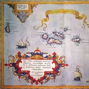
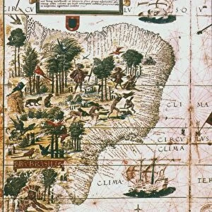
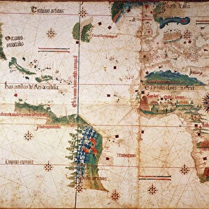
Poster Print : BRAZIL: MAP AND NATIVE INDIANS. Portuguese map of Brazil, 1565, depicting a family of native Indians, one of whom is harvesting brazilwood trees (probably Caesalpinia echinata


![]()
Poster Prints from Granger
BRAZIL: MAP AND NATIVE INDIANS. Portuguese map of Brazil, 1565, depicting a family of native Indians, one of whom is harvesting brazilwood trees (probably Caesalpinia echinata
BRAZIL: MAP AND NATIVE INDIANS. Portuguese map of Brazil, 1565, depicting a family of native Indians, one of whom is harvesting brazilwood trees (probably Caesalpinia echinata or Sappan)
Granger holds millions of images spanning more than 25,000 years of world history, from before the Stone Age to the dawn of the Space Age
Media ID 6622151
1565 Age Of Discovery American Indian Brazil Brazilian New World Portolan Chart Portuguese
A4 (29.7 x 21cm) Poster Print
"Discover the rich history of Brazil with our stunning poster prints from the Media Storehouse collection. This captivating piece features a rare Portuguese map of Brazil from 1565, beautifully illustrating the early exploration of the land. The map is not only an intriguing representation of the geography of the time, but also showcases a native Indian family, adding a cultural dimension to this historical artifact. One member of the family is depicted harvesting brazilwood trees, a significant resource during the colonial era. Bring this piece of history into your home or office and transport yourself back in time. Order now from Media Storehouse and enjoy the highest quality print on premium paper."
Premium quality poster prints are printed on luxurious semi-gloss satin 270 gsm paper. Our meticulously crafted poster prints offer an affordable option for decorating any space, making them ideal for living rooms, bedrooms, offices and beyond. To ensure your poster arrives in good condition, we roll and send them in strong mailing tubes.
Poster prints are budget friendly enlarged prints in standard poster paper sizes (A0, A1, A2, A3 etc). Whilst poster paper is sometimes thinner and less durable than our other paper types, they are still ok for framing and should last many years. Our Archival Quality Photo Prints and Fine Art Paper Prints are printed on higher quality paper and the choice of which largely depends on your budget.
Estimated Product Size is 21.6cm x 30.3cm (8.5" x 11.9")
These are individually made so all sizes are approximate
Artwork printed orientated as per the preview above, with landscape (horizontal) or portrait (vertical) orientation to match the source image.
FEATURES IN THESE COLLECTIONS
> Granger Art on Demand
> Maps
> Arts
> Art Movements
> Renaissance Art
> Arts
> Landscape paintings
> Waterfall and river artworks
> River artworks
> Europe
> Portugal
> Related Images
> Maps and Charts
> Related Images
EDITORS COMMENTS
This print takes us back to the year 1565, offering a glimpse into the rich history of Brazil. The Portuguese map of Brazil beautifully illustrates the vastness and diversity of this South American country during the Renaissance period. As we delve deeper into this intricate artwork, our attention is drawn to a family of native Indians depicted within its borders. Intriguingly, one member of this indigenous family can be seen engaged in the meticulous process of harvesting brazilwood trees. These trees, most likely Caesalpinia echinata or Sappan species, hold great significance in Brazilian history as they were highly valued for their vibrant red dye known as "brazilin". This valuable resource played a crucial role in trade and commerce during that era. The map itself serves as both an informative tool and a work of art from the Age of Discovery. It showcases not only geographical features such as rivers but also provides insights into American Indian settlements across Brazil's vast landscape. As we explore this remarkable piece from The Granger Collection's archives, it invites us to reflect on Brazil's cultural heritage and its deep connection with nature. It reminds us that beyond being just lines on paper, maps have always been windows through which we can discover fascinating stories about our world and its diverse inhabitants.
MADE IN AUSTRALIA
Safe Shipping with 30 Day Money Back Guarantee
FREE PERSONALISATION*
We are proud to offer a range of customisation features including Personalised Captions, Color Filters and Picture Zoom Tools
SECURE PAYMENTS
We happily accept a wide range of payment options so you can pay for the things you need in the way that is most convenient for you
* Options may vary by product and licensing agreement. Zoomed Pictures can be adjusted in the Cart.

![Ouro Preto - [ World Heritage Site by UNESCO ]](/sq/629/ouro-preto-world-heritage-site-unesco-11983598.jpg.webp)