Poster Print > Europe > Croatia > Maps
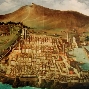
Poster Print : Dubrovnik. Map of the city before the earthquake of 1667


![]()
Poster Prints from Mary Evans Picture Library
Dubrovnik. Map of the city before the earthquake of 1667
Dubrovnik. Map of the city before the earthquake of 1667. Croatia
Mary Evans Picture Library makes available wonderful images created for people to enjoy over the centuries
Media ID 14340468
© Thaliastock / Mary Evans
Adriatic Cartography Contour Croatia Croatian Dalmatian Dubrovnik Mapping Pearl Perimeter Seventeenth Walled Xvii Xviith
A4 (29.7 x 21cm) Poster Print
Discover the rich history of Dubrovnik with our exquisite poster print from Media Storehouse. This captivating piece showcases an ancient map of the city, as it looked before the devastating earthquake of 1667. Sourced from Mary Evans Prints Online, this rights managed image offers a unique glimpse into the past, bringing history to life in your home or office space. Delve into the enchanting world of Dubrovnik's past, and adorn your walls with this intriguing and educational addition.
Premium quality poster prints are printed on luxurious semi-gloss satin 270 gsm paper. Our meticulously crafted poster prints offer an affordable option for decorating any space, making them ideal for living rooms, bedrooms, offices and beyond. To ensure your poster arrives in good condition, we roll and send them in strong mailing tubes.
Poster prints are budget friendly enlarged prints in standard poster paper sizes (A0, A1, A2, A3 etc). Whilst poster paper is sometimes thinner and less durable than our other paper types, they are still ok for framing and should last many years. Our Archival Quality Photo Prints and Fine Art Paper Prints are printed on higher quality paper and the choice of which largely depends on your budget.
Estimated Product Size is 30.3cm x 21.6cm (11.9" x 8.5")
These are individually made so all sizes are approximate
Artwork printed orientated as per the preview above, with landscape (horizontal) or portrait (vertical) orientation to match the source image.
FEATURES IN THESE COLLECTIONS
> Europe
> Croatia
> Related Images
> Maps and Charts
> Early Maps
> Maps and Charts
> Related Images
EDITORS COMMENTS
This print showcases a historic map of Dubrovnik before the devastating earthquake of 1667. The intricate details and precision of the cartography highlight the city's layout along the stunning Adriatic coast. This 17th-century map provides a glimpse into Dubrovnik's past, showcasing its walled perimeter, mountainous backdrop, and strategic location as a Dalmatian pearl.
The map serves as a window into history, offering insight into Dubrovnik's rich cultural heritage and architectural significance. The careful contouring of the city walls and streets reflects the meticulous craftsmanship of early modern mapping techniques.
Dubrovnik, often referred to as the "Pearl of the Adriatic," has long been admired for its beauty and resilience in the face of natural disasters such as earthquakes. This image captures a moment frozen in time before tragedy struck, preserving the city's historical footprint for future generations to appreciate.
As we gaze upon this piece of Croatian history, we are reminded of Dubrovnik's enduring spirit and timeless allure. It stands as a testament to human ingenuity and perseverance in the face of adversity, making it not just a map but a symbol of strength and resilience.
MADE IN AUSTRALIA
Safe Shipping with 30 Day Money Back Guarantee
FREE PERSONALISATION*
We are proud to offer a range of customisation features including Personalised Captions, Color Filters and Picture Zoom Tools
SECURE PAYMENTS
We happily accept a wide range of payment options so you can pay for the things you need in the way that is most convenient for you
* Options may vary by product and licensing agreement. Zoomed Pictures can be adjusted in the Cart.