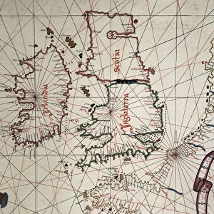
Poster Print : A map of Britain, mid 16th century


![]()
Poster Prints from Mary Evans Picture Library
A map of Britain, mid 16th century
A map of Britain in the mid 16th century, detailing Edinburgh, Dover, Cornwall, Waterford and London. Date: Mid 16th century
Mary Evans Picture Library makes available wonderful images created for people to enjoy over the centuries
Media ID 14221391
© Mary Evans Picture Library
1550s Dover Edinburgh Hibernia Places Scotia Waterford
A1 (84.1 x 59.4cm) Poster Print
Step back in time with our exquisite selection of Media Storehouse Poster Prints, featuring an intriguing map of Britain from the mid-16th century. This captivating antique map, sourced from Mary Evans Prints Online, offers a glimpse into the past with its detailed depiction of Edinburgh, Dover, Cornwall, Waterford, and London. Add an air of history and sophistication to any room with this stunning, rights-managed print. Discover the rich tapestry of Britain's past and bring a piece of history into your home or office.
Premium quality poster prints are printed on luxurious glossy or matte 270 gsm paper. Our meticulously crafted poster prints offer an affordable option for decorating any space, making them ideal for living rooms, bedrooms, offices and beyond. To ensure your poster arrives in good condition, we roll and send them in strong mailing tubes.
Poster prints are budget friendly enlarged prints in standard poster paper sizes (A0, A1, A2, A3 etc). Whilst poster paper is sometimes thinner and less durable than our other paper types, they are still ok for framing and should last many years. Our Archival Quality Photo Prints and Fine Art Paper Prints are printed on higher quality paper and the choice of which largely depends on your budget.
Estimated Image Size (if not cropped) is 84.6cm x 49.5cm (33.3" x 19.5")
Estimated Product Size is 84.6cm x 59.6cm (33.3" x 23.5")
These are individually made so all sizes are approximate
Artwork printed orientated as per the preview above, with landscape (horizontal) orientation to match the source image.
EDITORS COMMENTS
1. Title: "Exploring the Past: A Glimpse into Britain's Rich History through a Mid-16th Century Map" This map print, hailing from the mid-16th century, offers a fascinating glimpse into the geographical knowledge and cartographic skills of the time. The map meticulously details various regions of Britain, including Scotland, England, Wales, and Ireland, with a particular focus on Edinburgh, Dover, Cornwall, Waterford, and London. During the 1550s, as Europe was undergoing the Renaissance, cartography was also experiencing a revolution. Maps became more detailed and accurate, reflecting the growing interest in exploration and the expanding reach of European empires. This map, with its intricate depiction of the British Isles, is a testament to this era of cartographic innovation. Edinburgh, the capital city of Scotland, is shown nestled in the southeastern part of the country, while Dover, the easternmost point of England, is clearly marked. Cornwall, the most southwesterly part of England, is also visible, as is Waterford, an important Irish port city. London, the political and cultural heart of England, is prominently displayed in the southeastern part of the map. The map also includes the names of other significant places, such as Hibernia (Ireland) and Scotia (Scotland), reflecting the historical understanding of the British Isles. This map not only provides valuable insights into the geography of the time but also serves as a reminder of the rich history and cultural connections that bind the various regions of Britain. As we explore the intricacies of this map, we are transported back to the 16th century, a time of discovery, innovation, and the beginning of the modern world. This map is not just a historical artifact but a window into the past, inviting us to delve deeper into the stories and secrets that lie hidden within its lines and contours.
MADE IN AUSTRALIA
Safe Shipping with 30 Day Money Back Guarantee
FREE PERSONALISATION*
We are proud to offer a range of customisation features including Personalised Captions, Color Filters and Picture Zoom Tools
FREE COLORIZATION SERVICE
You can choose advanced AI Colorization for this picture at no extra charge!
SECURE PAYMENTS
We happily accept a wide range of payment options so you can pay for the things you need in the way that is most convenient for you
* Options may vary by product and licensing agreement. Zoomed Pictures can be adjusted in the Cart.