Poster Print > Europe > Portugal > Maps
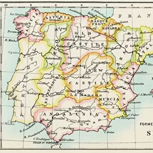
Poster Print : Map of the Kingdoms of Spain and Portugal


![]()
Poster Prints from Mary Evans Picture Library
Map of the Kingdoms of Spain and Portugal
Map of the Kingdoms of Spain and Portugal (prior to the Portuguese Revolution in 1910). Date: circa 1908
Mary Evans Picture Library makes available wonderful images created for people to enjoy over the centuries
Media ID 11548861
© Mary Evans / Grenville Collins Postcard Collection
Balearic Borders Ibiza Isalnds Kingdoms Mallorca Mediterranean Menorca Portugal Roads
A4 (29.7 x 21cm) Poster Print
Introducing the captivating "Map of the Kingdoms of Spain and Portugal" from our Media Storehouse Poster Prints collection. This beautifully detailed antique map, sourced from Mary Evans Prints Online, transports you back in time to the early 20th century. The map showcases the extensive territories of Spain and Portugal prior to the Portuguese Revolution in 1910. Add an air of historical intrigue to your space with this striking, vintage print. Perfect for history enthusiasts, educators, or anyone seeking to adorn their walls with a piece of the past. Bring the rich history of these European kingdoms into your home or office with our high-quality poster print.
Premium quality poster prints are printed on luxurious semi-gloss satin 270 gsm paper. Our meticulously crafted poster prints offer an affordable option for decorating any space, making them ideal for living rooms, bedrooms, offices and beyond. To ensure your poster arrives in good condition, we roll and send them in strong mailing tubes.
Poster prints are budget friendly enlarged prints in standard poster paper sizes (A0, A1, A2, A3 etc). Whilst poster paper is sometimes thinner and less durable than our other paper types, they are still ok for framing and should last many years. Our Archival Quality Photo Prints and Fine Art Paper Prints are printed on higher quality paper and the choice of which largely depends on your budget.
Estimated Image Size (if not cropped) is 30.3cm x 19.1cm (11.9" x 7.5")
Estimated Product Size is 30.3cm x 21.6cm (11.9" x 8.5")
These are individually made so all sizes are approximate
Artwork printed orientated as per the preview above, with landscape (horizontal) orientation to match the source image.
FEATURES IN THESE COLLECTIONS
> Europe
> Portugal
> Related Images
> Europe
> Spain
> Related Images
> Maps and Charts
> Early Maps
> Maps and Charts
> Related Images
> Maps and Charts
> Spain
EDITORS COMMENTS
1. Title: "A Vintage Glimpse into the Kingdoms of Spain and Portugal: A Map from the Early 20th Century" This vintage map print showcases the Kingdoms of Spain and Portugal as they existed prior to the Portuguese Revolution in 1910. Dated circa 1908, this map offers a historical perspective on the geographical layout of these European nations, their territories, and their borders along the Mediterranean Sea. The map highlights the intricate details of the Iberian Peninsula, with Spain occupying the majority of the landmass, and Portugal situated on the westernmost edge. The Balearic Islands, including Menorca, Mallorca, and Ibiza, are clearly marked in the Mediterranean Sea, showcasing their strategic importance in maritime trade and travel. The roads and borders depicted on the map provide a glimpse into the complex political landscape of the time. Spain's extensive territories, including its colonies in the Americas, are clearly delineated, while Portugal's holdings, such as its African colonies, are also indicated. The map also reveals the intricate border between the two nations, which has been a subject of historical disputes and negotiations. This map serves as a testament to the rich history of Spain and Portugal, their shared cultural heritage, and the complex geopolitical landscape of Europe during the early 20th century. It invites viewers to explore the historical context of this period and to appreciate the intricacies of the Iberian Peninsula's geography and political boundaries. Whether you are a history enthusiast, a collector of vintage maps, or simply someone who appreciates the beauty of historical cartography, this map print is a must-have addition to your collection. It offers a unique perspective on the past and serves as a reminder of the intricate connections between the present and the historical past.
MADE IN AUSTRALIA
Safe Shipping with 30 Day Money Back Guarantee
FREE PERSONALISATION*
We are proud to offer a range of customisation features including Personalised Captions, Color Filters and Picture Zoom Tools
SECURE PAYMENTS
We happily accept a wide range of payment options so you can pay for the things you need in the way that is most convenient for you
* Options may vary by product and licensing agreement. Zoomed Pictures can be adjusted in the Cart.