Poster Print > Arts > Landscape paintings > Forest and woodland scenes > Forest artwork
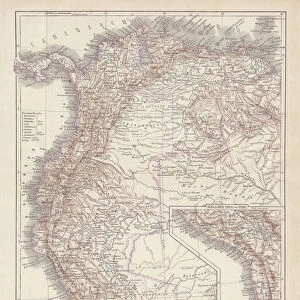
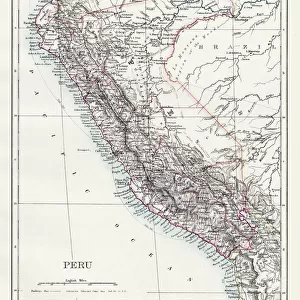
Poster Print : Map of Peru 1683 Mallet


![]()
Poster Prints from Mary Evans Picture Library
Map of Peru 1683 Mallet
Perou. A map showing a coastal part of South America on the South Pacific. Both the equator and tropic of Capricorn are given
Mary Evans Picture Library makes available wonderful images created for people to enjoy over the centuries
Media ID 589249
© Mary Evans Picture Library 2015 - https://copyrighthub.org/s0/hub1/creation/maryevans/MaryEvansPictureID/10173759
1683 Amazon Capricorn Equator Forest Mallet Maps Pacific Peru Rain Tropic Perou
A4 (29.7 x 21cm) Poster Print
Discover the rich history and geography of Peru with our stunning Map of Peru 1683 by Mallet from the Media Storehouse range of Poster Prints. This captivating antique map, sourced from Mary Evans Picture Library, presents a coastal section of South America on the South Pacific. Witness the intricate detailing of this beautifully aged map, which highlights the location of Peru and marks the positions of the equator and the tropic of Capricorn. Bring a piece of history into your home or office with this exquisite and informative poster print.
Premium quality poster prints are printed on luxurious semi-gloss satin 270 gsm paper. Our meticulously crafted poster prints offer an affordable option for decorating any space, making them ideal for living rooms, bedrooms, offices and beyond. To ensure your poster arrives in good condition, we roll and send them in strong mailing tubes.
Poster prints are budget friendly enlarged prints in standard poster paper sizes (A0, A1, A2, A3 etc). Whilst poster paper is sometimes thinner and less durable than our other paper types, they are still ok for framing and should last many years. Our Archival Quality Photo Prints and Fine Art Paper Prints are printed on higher quality paper and the choice of which largely depends on your budget.
Estimated Image Size (if not cropped) is 20.2cm x 30.3cm (8" x 11.9")
Estimated Product Size is 21.6cm x 30.3cm (8.5" x 11.9")
These are individually made so all sizes are approximate
Artwork printed orientated as per the preview above, with portrait (vertical) orientation to match the source image.
FEATURES IN THESE COLLECTIONS
> Arts
> Artists
> O
> Oceanic Oceanic
> Arts
> Landscape paintings
> Forest and woodland scenes
> Forest artwork
> Maps and Charts
> Early Maps
> Maps and Charts
> Related Images
> South America
> Peru
> Maps
> South America
> Peru
> Related Images
> South America
> Related Images
EDITORS COMMENTS
This historical map, titled "Perou" and dated 1683, is an intriguing glimpse into the cartographic knowledge of the coastal region of South America during the late 17th century. Produced by the renowned French cartographer Guillaume Sanson and published by Jean Baptiste Nolin, this map is an important representation of the geographical understanding of the area during this time. The map focuses on the coastal part of modern-day Peru, stretching from the northern tip of Ecuador to the southernmost point of Chile. The mapmaker meticulously delineates the rugged coastline, marking various bays, inlets, and capes with great detail. The vast expanse of the Pacific Ocean is depicted to the west, with the equator and the tropic of Capricorn clearly indicated. The Amazon River, the lifeblood of the region, is shown flowing into the Atlantic Ocean, adding to the map's richness and depth. The dense forested areas, teeming with diverse flora and fauna, are depicted with a sense of wonder and curiosity, reflecting the exploratory spirit of the time. The map also includes various place names, some of which are still in use today, such as the cities of Lima, Callao, and Arica. The cartouche at the bottom right corner features an elegant design, complete with a view of a coastal scene, a native American figure, and a European explorer, highlighting the interconnectedness of the Old and New Worlds during this period. This map, created by Guillaume Sanson and published by Jean Baptiste Nolin in 1683, is a valuable historical document that offers a fascinating glimpse into the cartographic knowledge and understanding of the coastal region of South America during the late 17th century. It is a testament to the rich history and diverse geography of the area, and a reminder of the exploratory spirit that drove the cartographic endeavors of the time.
MADE IN AUSTRALIA
Safe Shipping with 30 Day Money Back Guarantee
FREE PERSONALISATION*
We are proud to offer a range of customisation features including Personalised Captions, Color Filters and Picture Zoom Tools
SECURE PAYMENTS
We happily accept a wide range of payment options so you can pay for the things you need in the way that is most convenient for you
* Options may vary by product and licensing agreement. Zoomed Pictures can be adjusted in the Cart.