Poster Print > Africa > South Africa > Maps
Poster Print : Map /s Africa / Boer C1898


![]()
Poster Prints from Mary Evans Picture Library
Map /s Africa / Boer C1898
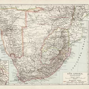
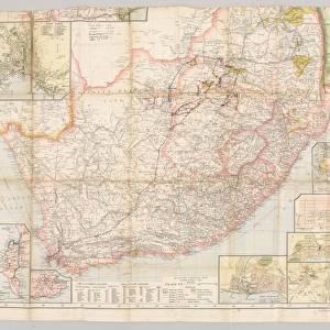
SOUTH AFRICA on the eve of the Boer War
Mary Evans Picture Library makes available wonderful images created for people to enjoy over the centuries
Media ID 571757
© Mary Evans Picture Library 2015 - https://copyrighthub.org/s0/hub1/creation/maryevans/MaryEvansPictureID/10004464
A4 (29.7 x 21cm) Poster Print
Discover the rich history of South Africa on the eve of the Boer War with our stunning poster print from Mary Evans Picture Library. This captivating image, titled "Map /s Africa / Boer C1898," transports you back in time, offering a glimpse into the political landscape of the late 19th century. Bring the intriguing story of South Africa's turbulent past into your home or office with this beautifully detailed and authentic reproduction. Perfect for history enthusiasts, educators, and anyone with an appreciation for the world's diverse stories, this poster print is a must-have addition to your collection. Produced by the renowned Mary Evans Picture Library, this high-quality print offers excellent color accuracy and fine detail, ensuring a visually striking and engaging display. Embrace the allure of history and add this captivating piece to your wall today.
Premium quality poster prints are printed on luxurious semi-gloss satin 270 gsm paper. Our meticulously crafted poster prints offer an affordable option for decorating any space, making them ideal for living rooms, bedrooms, offices and beyond. To ensure your poster arrives in good condition, we roll and send them in strong mailing tubes.
Poster prints are budget friendly enlarged prints in standard poster paper sizes (A0, A1, A2, A3 etc). Whilst poster paper is sometimes thinner and less durable than our other paper types, they are still ok for framing and should last many years. Our Archival Quality Photo Prints and Fine Art Paper Prints are printed on higher quality paper and the choice of which largely depends on your budget.
Estimated Product Size is 30.3cm x 21.6cm (11.9" x 8.5")
These are individually made so all sizes are approximate
Artwork printed orientated as per the preview above, with landscape (horizontal) or portrait (vertical) orientation to match the source image.
FEATURES IN THESE COLLECTIONS
> Africa
> Related Images
> Africa
> South Africa
> Maps
> Africa
> South Africa
> Related Images
> Maps and Charts
> Early Maps
> Maps and Charts
> Related Images
EDITORS COMMENTS
This historical map print, titled "Map of South Africa, circa 1898: On the Eve of the Boer War," offers a fascinating glimpse into the geopolitical landscape of South Africa just prior to the outbreak of the Second Boer War. The map, from Mary Evans Picture Library, depicts the region with remarkable detail, highlighting the various territories controlled by the British, the Boers, and other European powers. The Boer Wars, a series of conflicts between the British and the Dutch-speaking Boer farmers, began in 1899 and lasted until 1902. This map, produced in 1898, provides a snapshot of the political situation in the region at the height of tensions between the British and the Boers. The map shows the British colonies of the Cape Colony, Natal, and the Transvaal and Orange Free State, which were governed by the Boers. The map also illustrates the various borders and territories claimed by European powers, including Germany and Portugal. The map's intricate detail includes the location of major cities, rivers, mountains, and roads, making it an invaluable resource for scholars and historians studying the period. The map also includes annotations indicating the location of important historical sites, such as the Battle of Majuba Hill, which took place in 1881 and is considered the beginning of the First Boer War. The "Map of South Africa, circa 1898: On the Eve of the Boer War" is a testament to the rich history of South Africa and the complex political situation that led to the conflicts between the British and the Boers. It offers a unique perspective on a pivotal moment in history and is a must-have for any collection focused on African history or the history of colonialism.
MADE IN AUSTRALIA
Safe Shipping with 30 Day Money Back Guarantee
FREE PERSONALISATION*
We are proud to offer a range of customisation features including Personalised Captions, Color Filters and Picture Zoom Tools
SECURE PAYMENTS
We happily accept a wide range of payment options so you can pay for the things you need in the way that is most convenient for you
* Options may vary by product and licensing agreement. Zoomed Pictures can be adjusted in the Cart.