Poster Print > Science > Space Exploration > Planets > Earth
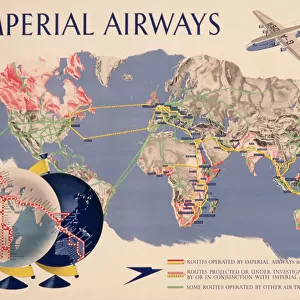
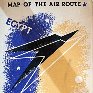
Poster Print : Route map, Imperial Airways


![]()
Poster Prints from Mary Evans Picture Library
Route map, Imperial Airways
Route map, Imperial Airways.
1938
Mary Evans Picture Library makes available wonderful images created for people to enjoy over the centuries
Media ID 14376332
© Mary Evans Picture Library/Onslow Auctions Limited
1938 Airline Airlines Airways Earth Global Globe Maps Passengers Planet Route Routes
A4 (29.7 x 21cm) Poster Print
"Step back in time with our vintage Imperial Airways Route Map print from Mary Evans Picture Library/Onslow Auctions Limited. This captivating poster, dating back to 1938, showcases the extensive network of Imperial Airways with intricate detail and elegant design. Bring a piece of aviation history into your home or office with this beautifully preserved and authentic poster from the Media Storehouse collection of prints. Perfect for aviation enthusiasts, travel lovers, or anyone looking to add a touch of nostalgia to their space."
Premium quality poster prints are printed on luxurious semi-gloss satin 270 gsm paper. Our meticulously crafted poster prints offer an affordable option for decorating any space, making them ideal for living rooms, bedrooms, offices and beyond. To ensure your poster arrives in good condition, we roll and send them in strong mailing tubes.
Poster prints are budget friendly enlarged prints in standard poster paper sizes (A0, A1, A2, A3 etc). Whilst poster paper is sometimes thinner and less durable than our other paper types, they are still ok for framing and should last many years. Our Archival Quality Photo Prints and Fine Art Paper Prints are printed on higher quality paper and the choice of which largely depends on your budget.
Estimated Image Size (if not cropped) is 30.3cm x 19.4cm (11.9" x 7.6")
Estimated Product Size is 30.3cm x 21.6cm (11.9" x 8.5")
These are individually made so all sizes are approximate
Artwork printed orientated as per the preview above, with landscape (horizontal) orientation to match the source image.
FEATURES IN THESE COLLECTIONS
> Maps and Charts
> Related Images
> Maps and Charts
> World
> Science
> Space Exploration
> Planets
> Earth
EDITORS COMMENTS
1. Title: Imperial Airways Route Map, 1938 This vintage print showcases the extensive global reach of Imperial Airways, a pioneering British airline that revolutionized air transport during the 1930s. The map, dated 1938, illustrates the intricate network of routes that connected various corners of the world, offering a glimpse into the golden age of aviation. The map is adorned with a rich, earthy tone, evoking a sense of adventure and exploration. The intricate lines and colorful pins mark the diverse destinations served by Imperial Airways, which spanned Europe, the Middle East, Africa, India, and the Far East. The routes crisscross continents, weaving together a complex web of connections that linked distant lands and brought the world closer together. The map's design is both functional and aesthetically pleasing, with a clear and easy-to-read layout. The use of a world map as the background adds a sense of scale, emphasizing the global scope of Imperial Airways' operations. The inclusion of various points of interest, such as major cities and landmarks, further enhances the visual appeal and historical significance of the print. The 1930s were a pivotal period in the history of air travel, as advancements in technology and infrastructure made flying increasingly accessible to the masses. Imperial Airways, with its extensive network and commitment to innovation, played a crucial role in shaping the aviation industry and making the world a smaller place. This Imperial Airways Route Map, 1938, is an invaluable historical artifact that offers a fascinating glimpse into the past and the evolution of air transport. It serves as a reminder of the wonder and excitement that accompanied early air travel and the role it played in connecting people and cultures around the world.
MADE IN AUSTRALIA
Safe Shipping with 30 Day Money Back Guarantee
FREE PERSONALISATION*
We are proud to offer a range of customisation features including Personalised Captions, Color Filters and Picture Zoom Tools
SECURE PAYMENTS
We happily accept a wide range of payment options so you can pay for the things you need in the way that is most convenient for you
* Options may vary by product and licensing agreement. Zoomed Pictures can be adjusted in the Cart.