Poster Print > Universal Images Group (UIG) > Illustrations > Illustrations 1
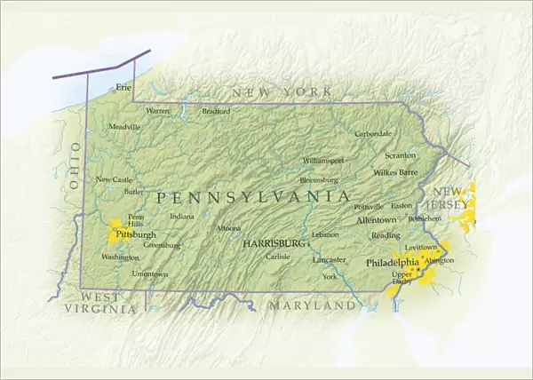
Poster Print : Map of Pennsylvania, close-up


![]()
Poster Prints from Universal Images Group (UIG)
Map of Pennsylvania, close-up
Universal Images Group (UIG) manages distribution for many leading specialist agencies worldwide
Media ID 9540177
© Dorling Kindersley/UIG
Digitally Generated Direction Guidance Pennsylvania State Text Us State Border Western Script
A4 (29.7 x 21cm) Poster Print
Discover the intricate details of Pennsylvania with our stunning Map of Pennsylvania, close-up print from Dorling Kindersley at Media Storehouse. This captivating image, provided by Universal Images Group (UIG), offers a unique perspective of the Keystone State's geography. Bring history and geography to life in your home or office with this beautiful and informative poster print. Order now and immerse yourself in the rich details of Pennsylvania's topography.
Premium quality poster prints are printed on luxurious semi-gloss satin 270 gsm paper. Our meticulously crafted poster prints offer an affordable option for decorating any space, making them ideal for living rooms, bedrooms, offices and beyond. To ensure your poster arrives in good condition, we roll and send them in strong mailing tubes.
Poster prints are budget friendly enlarged prints in standard poster paper sizes (A0, A1, A2, A3 etc). Whilst poster paper is sometimes thinner and less durable than our other paper types, they are still ok for framing and should last many years. Our Archival Quality Photo Prints and Fine Art Paper Prints are printed on higher quality paper and the choice of which largely depends on your budget.
Estimated Image Size (if not cropped) is 30.3cm x 20.2cm (11.9" x 8")
Estimated Product Size is 30.3cm x 21.6cm (11.9" x 8.5")
These are individually made so all sizes are approximate
Artwork printed orientated as per the preview above, with landscape (horizontal) orientation to match the source image.
EDITORS COMMENTS
This print titled "Map of Pennsylvania, close-up" takes us on a visual journey through the diverse landscapes and intricate details that define this northeastern state of the United States. With its vibrant colors and precise cartography, this digitally generated illustration by Dorling Kindersley showcases the physical geography of Pennsylvania in all its glory. The map's horizontal orientation allows for an immersive experience as we explore every nook and cranny of this remarkable state. From the rolling hills to the majestic mountains, from bustling cities to quaint towns, each element is meticulously depicted with Western script labels providing guidance along our exploration. As we delve deeper into this artwork, it becomes evident that it serves not only as a mere representation but also as a gateway to understanding Pennsylvania's rich history and cultural heritage. The state borders are clearly demarcated, reminding us of its place within the larger tapestry of America. With no people present in the image, our focus is solely on appreciating the beauty and complexity inherent in Pennsylvania's topography. This stunning print invites us to marvel at nature's wonders while simultaneously igniting curiosity about what lies beyond each contour line. Whether you're a resident or an admirer from afar, this visually striking map offers both aesthetic pleasure and valuable insights into one of America's most fascinating states – Pennsylvania.
MADE IN AUSTRALIA
Safe Shipping with 30 Day Money Back Guarantee
FREE PERSONALISATION*
We are proud to offer a range of customisation features including Personalised Captions, Color Filters and Picture Zoom Tools
SECURE PAYMENTS
We happily accept a wide range of payment options so you can pay for the things you need in the way that is most convenient for you
* Options may vary by product and licensing agreement. Zoomed Pictures can be adjusted in the Cart.