Poster Print > Universal Images Group (UIG) > Universal Images Group > Satellite and Aerial > Planet Observer 4
Poster Print : District of Braga, Portugal, Relief Map


![]()
Poster Prints from Universal Images Group (UIG)
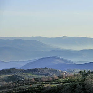
District of Braga, Portugal, Relief Map
Relief map of the district of Braga, Portugal. This image was compiled from data acquired by LANDSAT 5 & 7 satellites combined with elevation data
Universal Images Group (UIG) manages distribution for many leading specialist agencies worldwide
Media ID 9619143
© Planet Observer/UIG
Coastline District Portugal Relief Map Shore Braga Satellite View
A4 (29.7 x 21cm) Poster Print
Discover the beauty of Portugal's District of Braga with our stunning Relief Map Poster Print from Media Storehouse, in partnership with Universal Images Group (UIG). This intricately detailed map, derived from data collected by LANDSAT 5 & 7 satellites and elevation data, showcases the unique topography of the region. Bring the captivating landscape of Braga into your home or office and add an educational and visually appealing touch to your space.
Premium quality poster prints are printed on luxurious semi-gloss satin 270 gsm paper. Our meticulously crafted poster prints offer an affordable option for decorating any space, making them ideal for living rooms, bedrooms, offices and beyond. To ensure your poster arrives in good condition, we roll and send them in strong mailing tubes.
Poster prints are budget friendly enlarged prints in standard poster paper sizes (A0, A1, A2, A3 etc). Whilst poster paper is sometimes thinner and less durable than our other paper types, they are still ok for framing and should last many years. Our Archival Quality Photo Prints and Fine Art Paper Prints are printed on higher quality paper and the choice of which largely depends on your budget.
Estimated Product Size is 30.3cm x 21.6cm (11.9" x 8.5")
These are individually made so all sizes are approximate
Artwork printed orientated as per the preview above, with landscape (horizontal) or portrait (vertical) orientation to match the source image.
EDITORS COMMENTS
This print showcases the stunning district of Braga, Portugal, in all its topographical glory. Created from a compilation of data acquired by LANDSAT 5 & 7 satellites, combined with elevation information, this relief map offers an intricate and detailed view of the region's physical geography. The image presents a horizontal perspective that allows viewers to immerse themselves in Braga's diverse landscape. From the rugged coastline that stretches along the shore to the undulating hills and valleys further inland, every contour is beautifully captured. The vibrant colors employed in this cartographic representation bring life to each distinct feature. With no people present in the photograph, one can truly appreciate nature's grandeur as it unfolds across Braga. This outdoor scene invites exploration and sparks curiosity about what lies beyond its borders. As one gazes upon this satellite view of Portugal's enchanting district, they are transported into a world where land meets sea and history intertwines with natural beauty. Whether you have an affinity for photography or possess an interest in European destinations, this print serves as both a decorative piece and an educational tool. It provides a unique insight into Braga's topography while showcasing Universal Images Group (UIG)'s commitment to delivering high-quality imagery that captivates audiences worldwide.
MADE IN AUSTRALIA
Safe Shipping with 30 Day Money Back Guarantee
FREE PERSONALISATION*
We are proud to offer a range of customisation features including Personalised Captions, Color Filters and Picture Zoom Tools
SECURE PAYMENTS
We happily accept a wide range of payment options so you can pay for the things you need in the way that is most convenient for you
* Options may vary by product and licensing agreement. Zoomed Pictures can be adjusted in the Cart.