
Poster Print > Universal Images Group (UIG) > Universal Images Group > Satellite and Aerial > Planet Observer 4
Poster Print : Region of Apulia, Italy, Relief Map


![]()
Poster Prints from Universal Images Group (UIG)
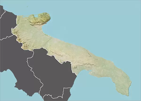
Region of Apulia, Italy, Relief Map
Relief map of the region of Apulia, Italy. This image was compiled from data acquired by LANDSAT 5 & 7 satellites combined with elevation data
Universal Images Group (UIG) manages distribution for many leading specialist agencies worldwide
Media ID 9619021
© Planet Observer/UIG
Apulia Bari Coastline Relief Map Shore Satellite View
A4 (29.7 x 21cm) Poster Print
Discover the breathtaking geography of Apulia, Italy with our Media Storehouse Poster Prints. This stunning Relief Map of the region, sourced from Universal Images Group (UIG), is meticulously compiled from satellite data acquired by LANDSAT 5 & 7, combined with elevation information. Explore the intricacies of the Apulian terrain with lifelike topography, bringing a piece of Italy's natural beauty into your home or office space. Order now and embark on a captivating journey through the landscapes of Apulia.
Premium quality poster prints are printed on luxurious semi-gloss satin 270 gsm paper. Our meticulously crafted poster prints offer an affordable option for decorating any space, making them ideal for living rooms, bedrooms, offices and beyond. To ensure your poster arrives in good condition, we roll and send them in strong mailing tubes.
Poster prints are budget friendly enlarged prints in standard poster paper sizes (A0, A1, A2, A3 etc). Whilst poster paper is sometimes thinner and less durable than our other paper types, they are still ok for framing and should last many years. Our Archival Quality Photo Prints and Fine Art Paper Prints are printed on higher quality paper and the choice of which largely depends on your budget.
Estimated Product Size is 30.3cm x 21.6cm (11.9" x 8.5")
These are individually made so all sizes are approximate
Artwork printed orientated as per the preview above, with landscape (horizontal) or portrait (vertical) orientation to match the source image.
EDITORS COMMENTS
This print showcases the stunning region of Apulia, Italy, in all its geographical glory. The relief map, compiled from data acquired by LANDSAT 5 & 7 satellites combined with elevation data, offers a unique perspective on this picturesque area. With its vibrant colors and intricate details, the image beautifully captures the topography of Apulia. Stretching along the enchanting shores of Italy's eastern coast, Apulia is known for its diverse landscapes and rich history. From rolling hills to rugged cliffs and sandy beaches, this region boasts a remarkable blend of natural beauty. This print allows viewers to appreciate the physical geography of Apulia from a satellite view. The horizontal composition emphasizes the vastness of this European gem while highlighting its coastal charm. As no people are present in the image, it invites viewers to imagine themselves exploring these scenic surroundings firsthand. Whether you're an avid cartographer or simply captivated by Italy's allure, this print is sure to pique your interest. It serves as both an informative tool for studying regional maps and a visually striking piece that would enhance any space with its colorful depiction of Apulia's landscape
MADE IN AUSTRALIA
Safe Shipping with 30 Day Money Back Guarantee
FREE PERSONALISATION*
We are proud to offer a range of customisation features including Personalised Captions, Color Filters and Picture Zoom Tools
SECURE PAYMENTS
We happily accept a wide range of payment options so you can pay for the things you need in the way that is most convenient for you
* Options may vary by product and licensing agreement. Zoomed Pictures can be adjusted in the Cart.