Poster Print > Europe > United Kingdom > England > Sussex > Upper Beeding
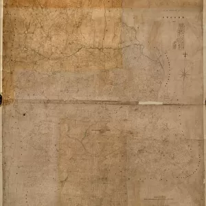
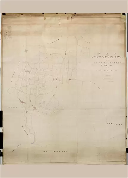
Poster Print : Upper Beeding Tithe Map, 1842


![]()
Poster Prints from West Sussex County Council
Upper Beeding Tithe Map, 1842
By J. & E. Smith, Surveyors. 26.6 in. to 1 m. Original Map Size 112in. × 94in.
Tithe Award Map Collection
West Sussex Record Office Ref No: TD/W165
West Sussex County Council Record Office contains a fascinating history of the county of West Sussex, England
Media ID 7915654
© West Sussex County Council - All Rights Reserved
1840s Historical Mapping Parish
A3 (42 x 29.7cm) Poster Print
"Discover the history of Upper Beeding with our stunning poster print from the Media Storehouse collection. This beautifully detailed reproduction showcases the Upper Beeding Tithe Map from 1842, originally created by J. & E. Smith, Surveyors for the West Sussex Record Office. Explore the intricacies of this historic map, a valuable piece of West Sussex heritage now available as a high-quality poster print to adorn your walls and inspire curiosity in generations to come."
Premium quality poster prints are printed on luxurious semi-gloss satin 270 gsm paper. Our meticulously crafted poster prints offer an affordable option for decorating any space, making them ideal for living rooms, bedrooms, offices and beyond. To ensure your poster arrives in good condition, we roll and send them in strong mailing tubes.
Poster prints are budget friendly enlarged prints in standard poster paper sizes (A0, A1, A2, A3 etc). Whilst poster paper is sometimes thinner and less durable than our other paper types, they are still ok for framing and should last many years. Our Archival Quality Photo Prints and Fine Art Paper Prints are printed on higher quality paper and the choice of which largely depends on your budget.
Estimated Product Size is 30.6cm x 42.6cm (12" x 16.8")
These are individually made so all sizes are approximate
Artwork printed orientated as per the preview above, with portrait (vertical) orientation to match the source image.
FEATURES IN THESE COLLECTIONS
> Europe
> United Kingdom
> England
> Sussex
> Related Images
> Europe
> United Kingdom
> England
> Sussex
> Upper Beeding
> Europe
> United Kingdom
> England
> West Sussex
> Related Images
> Maps and Charts
> Early Maps
> Maps and Charts
> Related Images
> West Sussex County Council
> West Sussex Record Office
> Tithe Award Maps, 1808-1859
EDITORS COMMENTS
This print showcases the Upper Beeding Tithe Map from 1842, a remarkable piece of historical mapping that offers a glimpse into the past. Created by esteemed surveyors J. & E. Smith, this map is an impressive feat of cartography with its original size measuring an astounding 112 inches by 94 inches. The Upper Beeding Tithe Map holds immense significance as it provides valuable insights into the parish during the 1840s. It serves as a window to a bygone era, allowing us to explore and understand how this area in West Sussex was structured and utilized at that time. Preserved within the renowned Tithe Award Map Collection at the West Sussex Record Office, this print represents an invaluable resource for researchers, historians, and anyone interested in delving deep into local history. Its meticulous details offer a comprehensive overview of land ownership, boundaries, and usage patterns prevalent during that period. It is important to note that this caption focuses solely on providing information about the photograph itself and does not mention any commercial use or reference to any specific company associated with it. The intent is solely to highlight the historical significance of this particular map within West Sussex County Council's collection for educational purposes.
MADE IN AUSTRALIA
Safe Shipping with 30 Day Money Back Guarantee
FREE PERSONALISATION*
We are proud to offer a range of customisation features including Personalised Captions, Color Filters and Picture Zoom Tools
SECURE PAYMENTS
We happily accept a wide range of payment options so you can pay for the things you need in the way that is most convenient for you
* Options may vary by product and licensing agreement. Zoomed Pictures can be adjusted in the Cart.