Home > Popular Themes > Olympics
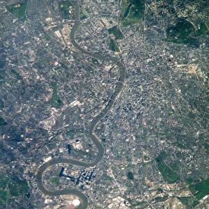
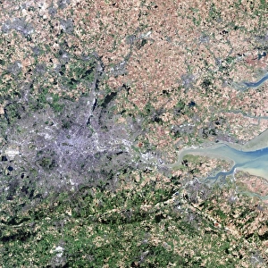
Flood risk in London, satellite image

![]()
Wall Art and Photo Gifts from Science Photo Library
Flood risk in London, satellite image
Flood risk in London. Satellite image of central London illustrating the areas at risk of flooding due to a rise in sea-level. North is at top. Global sea-level is predicted to rise by up to a metre over the next hundred years. Such a rise would cause much of central London to be inundated. In this image, the areas most at risk are shaded. This land is at or below the 10 metre contour line. Important areas at risk include the Houses of Parliament and Whitehall, which are situated on the north bank of the River Thames (brown), just below the bend at centre left. Stratford (shaded area at upper right) is situated near the banks of the River Lea, a tributary of the Thames. It is is where the Olympic Village of the 2012 Olympics is located
Science Photo Library features Science and Medical images including photos and illustrations
Media ID 6373225
© GETMAPPING PLC/SCIENCE PHOTO LIBRARY
Capital Central City Climate Climate Change Climatological Climatology Devastation Flood Flooding From Space Future Global Warming Levels Meteorological Meteorology Potential Rise Rising Risk River Satellite Satellite Image Sea Level Weather Inundated Inundation Projected
EDITORS COMMENTS
This satellite image captures the flood risk in London, highlighting the potential devastation that could occur due to a rise in sea-level. With global sea-level predicted to increase by up to a metre over the next century, much of central London is at risk of being inundated. The shaded areas in this image represent land that sits at or below the 10-metre contour line, making them particularly vulnerable. Notable landmarks such as the Houses of Parliament and Whitehall can be seen on the north bank of the River Thames, just below the bend towards centre left. These important areas are situated within the brown-shaded region and face significant danger from flooding. Another area depicted here is Stratford, located near the banks of River Lea – a tributary of Thames – where the Olympic Village for 2012 Olympics was constructed. This photograph serves as a stark reminder of how climate change and rising sea levels pose serious threats to our world's major cities. As we continue to witness global warming's impact on our planet, it becomes crucial for governments and communities alike to prioritize measures aimed at mitigating these risks. By understanding and addressing flood-prone regions like those shown here, we can work towards building more resilient cities capable of withstanding future challenges posed by changing climatic conditions.
MADE IN AUSTRALIA
Safe Shipping with 30 Day Money Back Guarantee
FREE PERSONALISATION*
We are proud to offer a range of customisation features including Personalised Captions, Color Filters and Picture Zoom Tools
SECURE PAYMENTS
We happily accept a wide range of payment options so you can pay for the things you need in the way that is most convenient for you
* Options may vary by product and licensing agreement. Zoomed Pictures can be adjusted in the Cart.