Southern United Kingdom

![]()
Wall Art and Photo Gifts from Science Photo Library
Southern United Kingdom
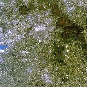
Southern United Kingdom (UK). Satellite image of the southern part of the UK. North is at top. This view is about 560 kilometres across, stretching from the south-western tip of Cornwall (lower left corner) to the Normandy coast in France (lower right corner). The English Channel (La Manche) separates southern England from north-western France. From south-north, the view covers about 450 kilometres, reaching up to the cities of Liverpool, Manchester and Sheffield (grey areas across top). London, the capital city of the UK, is the large grey area at lower right, to the left of the Thames Estuary (light blue, centre right). The Bristol Channel (grey-blue, lower left) is below Wales (land area at upper left). Birmingham (grey, upper centre) is to the east of Wales
Science Photo Library features Science and Medical images including photos and illustrations
Media ID 6349095
© PLANETOBSERVER/SCIENCE PHOTO LIBRARY
Birmingham Bristol Bristol Channel British Isles Channel Cities City Coast Coastal Country Earth Observation English Channel Estuary French From Space Great Britain Irish Sea Island Land Liverpool Manchester Midlands Nation North Sea River Rivers Satellite Satellite Image Sheffield South Southern Strait Thames Thames Estuary Wales Bays Cardigan Bay Counties Home Counties La Manche Normandy Coast Severn Severn Estuary Shire Shires The Wash
EDITORS COMMENTS
This stunning satellite image captures the breathtaking beauty of the Southern United Kingdom. With a width of approximately 560 kilometers, this view showcases the diverse landscapes and vibrant cities that make up this region. From the picturesque coastline of Cornwall in the southwest to the charming Normandy coast in France, this print highlights the connection between southern England and northwestern France through the English Channel. Moving from south to north, you can trace your eyes across approximately 450 kilometers, passing through iconic cities such as Liverpool, Manchester, and Sheffield. London, proudly standing as the capital city of UK, dominates the lower right corner with its vast urban expanse nestled beside the Thames Estuary. The Bristol Channel lies gracefully below Wales while Birmingham sits majestically towards its east. This image encapsulates not only geographical features but also cultural significance as it encompasses counties, shires, rivers like Severn and Thames Estuary along with their estuaries. As an Earth observation taken from space in our modern era, this satellite image offers a unique perspective on British Isles' coastal geography. It portrays a harmonious blend of land and sea that characterizes southern England's charm. Let yourself be captivated by this remarkable visual representation brought to you by Science Photo Library – an awe-inspiring testament to Britain's natural wonders.
MADE IN AUSTRALIA
Safe Shipping with 30 Day Money Back Guarantee
FREE PERSONALISATION*
We are proud to offer a range of customisation features including Personalised Captions, Color Filters and Picture Zoom Tools
SECURE PAYMENTS
We happily accept a wide range of payment options so you can pay for the things you need in the way that is most convenient for you
* Options may vary by product and licensing agreement. Zoomed Pictures can be adjusted in the Cart.