Home > Maps and Charts > Abraham Ortelius
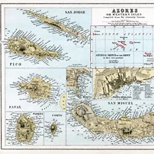
Map of Azores by Abraham Ortelius, 1528-1598, from Theatrum Orbis Terrarum, 1570

![]()
Wall Art and Photo Gifts from Universal Images Group (UIG)
Map of Azores by Abraham Ortelius, 1528-1598, from Theatrum Orbis Terrarum, 1570
Cartography, 16th century. Map of the Azores by Abraham Ortelius (1528-1598), from Theatrum Orbis Terrarum, 1570
Universal Images Group (UIG) manages distribution for many leading specialist agencies worldwide
Media ID 9501837
© DEA / G. DAGLI ORTI
16th Century Abraham Ortelius Archipelago Coastline Island Nautical Vessel Portugal Sailing Boat Theatrum Orbis Terrarum Western Script Azores
FEATURES IN THESE COLLECTIONS
> Maps and Charts
> Abraham Ortelius
> Universal Images Group (UIG)
> Art
> Painting, Sculpture & Prints
> Cartography
EDITORS COMMENTS
This print showcases the exquisite "Map of Azores" by Abraham Ortelius, a renowned cartographer from the 16th century. The map, originally published in 1570 as part of his masterpiece "Theatrum Orbis Terrarum" offers a fascinating glimpse into the archipelago's geography during that era. With its full-length view and front-facing perspective, this studio-shot image allows us to appreciate every intricate detail of Ortelius' work. The Azores, an enchanting group of islands located off the coast of Portugal, are beautifully depicted on this historical map. As we explore it further, our eyes are drawn to a sailing boat gracefully navigating through the surrounding sea. This addition not only adds depth to the composition but also emphasizes the importance of maritime exploration during that time. Ortelius' mastery in cartography is evident in this horizontal illustration and painting. The Western script used throughout provides additional authenticity to this piece of art and craft. With no people present in the image, our focus remains solely on appreciating Ortelius' skillful depiction of physical geography. This print serves as a testament to both Ortelius' legacy and his contribution to nautical navigation through his detailed maps. It invites us to embark on a journey back in time while marveling at how far cartography has come since then. Whether you're an avid historian or simply fascinated by ancient maps, this artwork is sure to captivate your imagination with its rich history
MADE IN AUSTRALIA
Safe Shipping with 30 Day Money Back Guarantee
FREE PERSONALISATION*
We are proud to offer a range of customisation features including Personalised Captions, Color Filters and Picture Zoom Tools
SECURE PAYMENTS
We happily accept a wide range of payment options so you can pay for the things you need in the way that is most convenient for you
* Options may vary by product and licensing agreement. Zoomed Pictures can be adjusted in the Cart.