Home > Arts > Landscape paintings > Waterfall and river artworks > River artworks
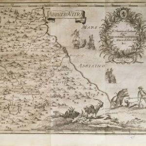
Map of coast of Venezuela, Gulf of Paria, mouth of Orinoco river, islands of Trinidad and Grenada By Juan Valdes, 1776

![]()
Wall Art and Photo Gifts from Universal Images Group (UIG)
Map of coast of Venezuela, Gulf of Paria, mouth of Orinoco river, islands of Trinidad and Grenada By Juan Valdes, 1776
Cartography, 18th century. Map of the coast of Venezuela, Gulf of Paria, mouth of the Orinoco river, islands of Trinidad and Grenada. By Juan Valdes, 1776
Universal Images Group (UIG) manages distribution for many leading specialist agencies worldwide
Media ID 9504937
© DEA PICTURE LIBRARY
18th Century Coastline Gulf Island Orinoco River Trinidad Venezuela Western Script Grenada
FEATURES IN THESE COLLECTIONS
> Arts
> Landscape paintings
> Waterfall and river artworks
> River artworks
> North America
> Grenada
> Maps
> South America
> Venezuela
> Maps
> Universal Images Group (UIG)
> Art
> Painting, Sculpture & Prints
> Cartography
EDITORS COMMENTS
This 18th-century map print takes us on a journey to the coast of Venezuela, where the Gulf of Paria meets the mouth of the mighty Orinoco River. Created by Juan Valdes in 1776, this exquisite piece of cartography showcases not only the intricate details of physical geography but also serves as a testament to the artistry and craftsmanship prevalent during that era. The map encompasses not only mainland Venezuela but also highlights two significant islands - Trinidad and Grenada. With its horizontal composition, it offers a comprehensive view of this coastal region, capturing every contour and curve with precision. The Western script used for labeling adds an air of authenticity to this historical artifact. In this studio shot, we are presented with a full-length view of Valdes' masterpiece. The absence of people allows us to focus solely on the beauty and intricacy displayed before us. It is evident that Valdes poured his heart into creating this work, combining both illustration and painting techniques seamlessly. As we gaze upon this remarkable piece from Universal Images Group (UIG), we can't help but appreciate how it encapsulates both scientific accuracy and artistic expression. This map print serves as a window into history, reminding us not only of our ever-evolving understanding of our world's geography but also celebrating the skillful craftsmanship that has shaped our collective knowledge throughout centuries past.
MADE IN AUSTRALIA
Safe Shipping with 30 Day Money Back Guarantee
FREE PERSONALISATION*
We are proud to offer a range of customisation features including Personalised Captions, Color Filters and Picture Zoom Tools
SECURE PAYMENTS
We happily accept a wide range of payment options so you can pay for the things you need in the way that is most convenient for you
* Options may vary by product and licensing agreement. Zoomed Pictures can be adjusted in the Cart.