Home > Universal Images Group (UIG) > Art > Painting, Sculpture & Prints > Cartography
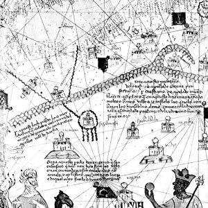
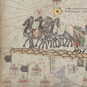
Merchants travelling to Cathay, China following in Marco Polos footsteps, from Catalan Atlas published for Charles V of France, attributed to Abraham and Jafuda Cresques Maiorca, circa 1375

![]()
Wall Art and Photo Gifts from Universal Images Group (UIG)
Merchants travelling to Cathay, China following in Marco Polos footsteps, from Catalan Atlas published for Charles V of France, attributed to Abraham and Jafuda Cresques Maiorca, circa 1375
Cartography, 14th century. Catalan Atlas published for Charles V of France, attributed to Abraham and Jafuda Cresques Maiorca (circa 1375). Merchants travelling to Cathay (China) following in Marco Polos footsteps
Universal Images Group (UIG) manages distribution for many leading specialist agencies worldwide
Media ID 9501415
© DEA PICTURE LIBRARY
14th Century Abraham Adventure Camel Catalan Flag Horse Large Group Of Animals Large Group Of People Merchant Miniature Charles V Majorca Marco Polo
EDITORS COMMENTS
This print takes us back in time to the 14th century, immersing us in a world of adventure and exploration. Attributed to Abraham and Jafuda Cresques Maiorca, this Catalan Atlas was published for Charles V of France around 1375. The image depicts merchants embarking on an epic journey to Cathay, China, following in the footsteps of the legendary Marco Polo. The scene is filled with intricate details that bring this historical moment to life. A large group of people can be seen traveling together, their determination evident as they traverse unknown lands. They are accompanied by a diverse array of animals - horses and camels - carrying their precious cargo. The map itself serves as a testament to the artistry and skill of these cartographers from Majorca. It showcases topography with precision while also capturing the spirit of exploration that defined this era. As we gaze upon this horizontal masterpiece, we cannot help but feel a sense of awe at the bravery and ambition displayed by those who dared venture into uncharted territories centuries ago. This illustration transports us back in time, allowing us to witness history unfold before our eyes. Let this image serve as a reminder that human curiosity knows no bounds; it drives us forward through adversity and propels us towards new horizons even when faced with uncertainty.
MADE IN AUSTRALIA
Safe Shipping with 30 Day Money Back Guarantee
FREE PERSONALISATION*
We are proud to offer a range of customisation features including Personalised Captions, Color Filters and Picture Zoom Tools
SECURE PAYMENTS
We happily accept a wide range of payment options so you can pay for the things you need in the way that is most convenient for you
* Options may vary by product and licensing agreement. Zoomed Pictures can be adjusted in the Cart.