Home > Arts > Artists > R > Jorge Reinel
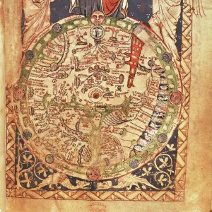
Map of Brazil, from Miller Atlas by Pedro and Jorge Reinel, Lopo Homen, cartographers and Antonio de Holanda, miniaturist, 1519

![]()
Wall Art and Photo Gifts from Universal Images Group (UIG)
Map of Brazil, from Miller Atlas by Pedro and Jorge Reinel, Lopo Homen, cartographers and Antonio de Holanda, miniaturist, 1519
Cartography, 16th century. Map of Brazil, from Miller Atlas, by Pedro and Jorge Reinel, Lopo Homen (cartographers) and Antonio de Holanda (miniaturist), 1519
Universal Images Group (UIG) manages distribution for many leading specialist agencies worldwide
Media ID 9503439
© DEA PICTURE LIBRARY
16th Century Brazil Coastline Miniature Tall Ship
FEATURES IN THESE COLLECTIONS
> Arts
> Artists
> R
> Jorge Reinel
> South America
> Brazil
> Maps
> Universal Images Group (UIG)
> Art
> Painting, Sculpture & Prints
> Illustration And Painting
EDITORS COMMENTS
This print showcases a remarkable piece of cartographic history - the Map of Brazil from the Miller Atlas, created by renowned cartographers Pedro and Jorge Reinel, along with miniaturist Antonio de Holanda in 1519. The map itself is a testament to the skill and artistry of these talented individuals. In this vertical composition, we are transported back to the 16th century, where intricate details come alive on paper. The map depicts Brazil's vast coastline, stretching as far as the eye can see. A towering tree stands proudly at its center, symbolizing both nature's grandeur and Brazil's rich biodiversity. The presence of a majestic tall ship sailing through calm waters reminds us of the era's exploration and discovery. It serves as a reminder that this map was not just an artistic creation but also a practical tool for navigation during those times. What makes this image even more fascinating is its absence of human representation. Without people present in the scene, we are left to imagine their journeys across uncharted territories or perhaps marvel at how much has changed since then. Overall, this print offers us a glimpse into history - it tells stories of adventure, curiosity about distant lands, and the incredible craftsmanship behind ancient maps like these. Whether you're interested in cartography or simply appreciate beautiful illustrations from centuries past, this image is sure to captivate your imagination.
MADE IN AUSTRALIA
Safe Shipping with 30 Day Money Back Guarantee
FREE PERSONALISATION*
We are proud to offer a range of customisation features including Personalised Captions, Color Filters and Picture Zoom Tools
SECURE PAYMENTS
We happily accept a wide range of payment options so you can pay for the things you need in the way that is most convenient for you
* Options may vary by product and licensing agreement. Zoomed Pictures can be adjusted in the Cart.