Home > Asia > Iran > Lakes > Caspian Sea
Iran, Relief Map With Border and Mask

![]()
Wall Art and Photo Gifts from Universal Images Group (UIG)
Iran, Relief Map With Border and Mask
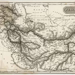
Relief map of Iran (with border and mask). This image was compiled from data acquired by landsat 5 & 7 satellites combined with elevation data
Universal Images Group (UIG) manages distribution for many leading specialist agencies worldwide
Media ID 9618887
© Planet Observer/UIG
Caspian Sea Coastline Desert Iran Middle East Persia Persian Gulf Relief Map Shore Satellite View Tehran
FEATURES IN THESE COLLECTIONS
> Aerial Photography
> Related Images
> Asia
> Iran
> Lakes
> Caspian Sea
> Universal Images Group (UIG)
> Universal Images Group
> Satellite and Aerial
> Planet Observer 4
EDITORS COMMENTS
This stunning print showcases the intricate topography of Iran, capturing its diverse landscapes and geographical features. Compiled from data acquired by landsat 5 & 7 satellites combined with elevation data, this relief map offers a detailed representation of Iran's physical geography. The image reveals the vastness of Iran's desert regions, stretching across the horizon in warm earth tones. The arid landscape is contrasted by the presence of a beautiful shoreline, where the land meets the Caspian Sea and Persian Gulf. The coastline curves gracefully along the edges, adding depth to this composition. Intriguingly, this relief map also includes Tehran, Iran's bustling capital city. Located in the horizontal middle section of the image, Tehran stands out as a vibrant urban center amidst nature's grandeur. The color palette used in this photograph enhances its visual appeal while maintaining an authentic representation of Iran's natural beauty. With no people present in this shot, it allows viewers to focus solely on appreciating and studying its geological formations. Whether you are fascinated by cartography or simply intrigued by different parts of our world, this print provides an immersive experience into Iran's unique terrain and showcases Universal Images Group (UIG)'s commitment to delivering exceptional photography that captures both artistry and scientific precision.
MADE IN AUSTRALIA
Safe Shipping with 30 Day Money Back Guarantee
FREE PERSONALISATION*
We are proud to offer a range of customisation features including Personalised Captions, Color Filters and Picture Zoom Tools
SECURE PAYMENTS
We happily accept a wide range of payment options so you can pay for the things you need in the way that is most convenient for you
* Options may vary by product and licensing agreement. Zoomed Pictures can be adjusted in the Cart.