Home > Europe > France > Canton > Bas Rhin
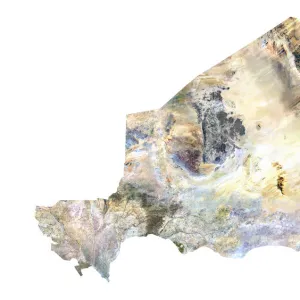
Togo, Satellite Image

![]()
Wall Art and Photo Gifts from Universal Images Group (UIG)
Togo, Satellite Image
Satellite view of Togo. This image was compiled from data acquired by LANDSAT satellite
Universal Images Group (UIG) manages distribution for many leading specialist agencies worldwide
Media ID 9615515
© Planet Observer
Alsace Bas Rhin Geographical Border Relief Map Satellite View
FEATURES IN THESE COLLECTIONS
> Europe
> France
> Canton
> Bas Rhin
> Europe
> France
> Canton
> Rhin
> Universal Images Group (UIG)
> Universal Images Group
> Satellite and Aerial
> Planet Observer 6
EDITORS COMMENTS
This print showcases the stunning satellite view of Togo, a country nestled in West Africa. Acquired by the remarkable LANDSAT satellite, this image offers a unique perspective on Togo's topography and physical geography. The vibrant colors beautifully depict the diverse landscape that stretches across this enchanting nation. From lush green forests to rolling hills and meandering rivers, every detail is meticulously captured in this photograph. The relief map allows viewers to appreciate the geographical borders that define Togo's boundaries with precision. With no people visible in the frame, one can truly immerse themselves in the natural beauty of this African gem. The vertical composition adds depth and dimension to the image while highlighting Togo's position within Europe. This particular print also includes Alsace, France - an intriguing contrast that sparks curiosity about their relationship or significance. Whether you are an avid cartographer or simply fascinated by Earth's wonders, this print from Universal Images Group (UIG) is sure to captivate your imagination. Its artistic blend of technology and nature invites us to explore new perspectives and gain a deeper appreciation for our planet's breathtaking landscapes
MADE IN AUSTRALIA
Safe Shipping with 30 Day Money Back Guarantee
FREE PERSONALISATION*
We are proud to offer a range of customisation features including Personalised Captions, Color Filters and Picture Zoom Tools
SECURE PAYMENTS
We happily accept a wide range of payment options so you can pay for the things you need in the way that is most convenient for you
* Options may vary by product and licensing agreement. Zoomed Pictures can be adjusted in the Cart.