Canvas Print > Europe > Hungary > Maps
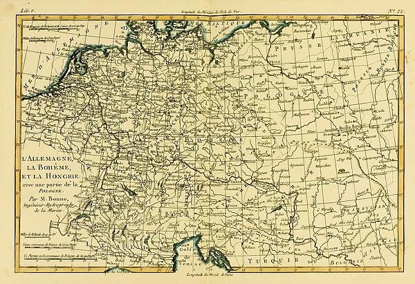
Canvas Print : Map Of Germany, Bohemia And Hungary, Circa. 1760. From "Atlas De Toutes Les Parties Connues Du Globe Terrestre "By Cartographer Rigobert Bonne. Published Geneva Circa. 1760


![]()
Canvas Prints from Design Pics
Map Of Germany, Bohemia And Hungary, Circa. 1760. From "Atlas De Toutes Les Parties Connues Du Globe Terrestre "By Cartographer Rigobert Bonne. Published Geneva Circa. 1760
Map Of Germany, Bohemia And Hungary, Circa.1760. From " Atlas De Toutes Les Parties Connues Du Globe Terrestre " By Cartographer Rigobert Bonne. Published Geneva Circa. 1760
Design Pics offers Distinctively Different Imagery representing over 1,500 contributors
Media ID 18186382
© Ken Welsh / Design Pics
Bohemia Cartography Geography Germany Hungary Mapmaking Plate
30"x20" (76x51cm) Canvas Print
Step back in time with our exquisite Canvas Print of an intricately detailed map of Germany, Bohemia, and Hungary, circa 1760. Originally from the "Atlas De Toutes Les Parties Connues Du Globe Terrestre" by renowned cartographer Rigobert Bonne, this map was published in Geneva around 1760. Each canvas print is meticulously reproduced from the original antique map, capturing every line, detail, and color with stunning accuracy. Add an air of historical charm to your home or office with this timeless piece of art.
Delivered stretched and ready to hang our premium quality canvas prints are made from a polyester/cotton blend canvas and stretched over a 1.25" (32mm) kiln dried knot free wood stretcher bar. Packaged in a plastic bag and secured to a cardboard insert for safe transit.
Canvas Prints add colour, depth and texture to any space. Professionally Stretched Canvas over a hidden Wooden Box Frame and Ready to Hang
Estimated Product Size is 76.2cm x 50.8cm (30" x 20")
These are individually made so all sizes are approximate
Artwork printed orientated as per the preview above, with landscape (horizontal) orientation to match the source image.
FEATURES IN THESE COLLECTIONS
> Europe
> Hungary
> Related Images
> Maps and Charts
> Related Images
EDITORS COMMENTS
This print showcases a beautifully detailed map of Germany, Bohemia, and Hungary from the year 1760. Created by the renowned cartographer Rigobert Bonne and published in Geneva during that era, this piece is a true testament to the artistry and precision of historical mapmaking. The vibrant colors and intricate engravings bring this map to life, allowing us to explore these European regions as they were over two centuries ago. The horizontal layout provides an expansive view of the landscape, inviting us to immerse ourselves in its rich history. As we examine each plate of this remarkable atlas, we are transported back in time when cartography was not only a scientific endeavor but also an artistic expression. Every line and contour on this map tells a story about the geography and topography of these lands. From bustling cities to serene countryside, every detail has been meticulously captured by Bonne's skilled hand. This print serves as both an educational tool for understanding past landscapes and a stunning work of art that can enhance any space it graces. Whether you have an interest in history or simply appreciate beautiful illustrations, this Map Of Germany, Bohemia And Hungary from "Atlas De Toutes Les Parties Connues Du Globe Terrestre" will undoubtedly captivate your imagination with its timeless charm.
MADE IN AUSTRALIA
Safe Shipping with 30 Day Money Back Guarantee
FREE PERSONALISATION*
We are proud to offer a range of customisation features including Personalised Captions, Color Filters and Picture Zoom Tools
SECURE PAYMENTS
We happily accept a wide range of payment options so you can pay for the things you need in the way that is most convenient for you
* Options may vary by product and licensing agreement. Zoomed Pictures can be adjusted in the Cart.