Canvas Print > Arts > Artists > W > Frederick de Wit
Canvas Print : Map of the Diocese of Liege (Belgium) (etching, 1671)
 (etching, 1671)")

 (etching, 1671)")


![]()
Canvas Prints from Fine Art Finder
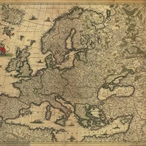
Map of the Diocese of Liege (Belgium) (etching, 1671)
LRI4710440 Map of the Diocese of Liege (Belgium) (etching, 1671) by Wit, Frederick de (1630-1706); Private Collection; (add.info.: Map of the Diocese of Liege (Belgium) - Strong water extracted from " Theatrum Orbis", 1671, by Frederick De Wit (Frederico de Witt) (1630-1706)); Luisa Ricciarini; Dutch, out of copyright
Media ID 22837392
© Luisa Ricciarini / Bridgeman Images
Atlas Book Cork Walloon Region Geographical Map
20"x16" (51x41cm) Canvas Print
Bring historical charm into your home with the Media Storehouse Canvas Print of the Map of the Diocese of Liege (Belgium) (etching, 1671). This exquisite piece, featuring the intricate etching by Wit, Frederick de, showcases the Diocese of Liege in Belgium as it appeared over 300 years ago. Meticulously reproduced on a canvas, this fine art print captures the intricate details of Luisa Ricciarini's image from Fine Art Finder. A perfect addition to any study, office, or living space, this canvas print adds an air of sophistication and historical depth to your decor.
Delivered stretched and ready to hang our premium quality canvas prints are made from a polyester/cotton blend canvas and stretched over a 1.25" (32mm) kiln dried knot free wood stretcher bar. Packaged in a plastic bag and secured to a cardboard insert for safe transit.
Canvas Prints add colour, depth and texture to any space. Professionally Stretched Canvas over a hidden Wooden Box Frame and Ready to Hang
Estimated Product Size is 50.8cm x 40.6cm (20" x 16")
These are individually made so all sizes are approximate
Artwork printed orientated as per the preview above, with landscape (horizontal) orientation to match the source image.
FEATURES IN THESE COLLECTIONS
> Arts
> Artists
> W
> Frederick de Wit
> Europe
> Belgium
> Related Images
> Maps and Charts
> Related Images
> Fine Art Finder
> Artists
> Frederick de Wit
> Fine Art Finder
> Artists
> Unknown Artist
EDITORS COMMENTS
This print showcases a remarkable etching from 1671, depicting the Map of the Diocese of Liege in Belgium. Created by Frederick de Wit, a renowned Dutch cartographer, this intricate map is an exquisite example of his mastery in geographical representation. The etching was extracted from "Theatrum Orbis" a significant work that showcased maps and atlases during that time. With its delicate details and precise engravings, this map offers a fascinating glimpse into the historical geography of Liege and its surrounding regions. It provides valuable insights into the Walloon region's topography during the 17th century, capturing both natural features and man-made structures with great accuracy. Preserved within a private collection, this rare piece holds immense cultural significance as it sheds light on Belgium's rich history. The strong water extraction technique used in creating this etching adds depth to every line and curve, further enhancing its visual appeal. Luisa Ricciarini has skillfully captured this extraordinary artwork through her lens, allowing us to appreciate its beauty even more. As we gaze upon this photograph print, we are transported back in time to an era where cartography played a vital role in understanding our world. This image serves as a testament to human curiosity and exploration while reminding us of the importance of preserving our past for future generations to cherish.
MADE IN AUSTRALIA
Safe Shipping with 30 Day Money Back Guarantee
FREE PERSONALISATION*
We are proud to offer a range of customisation features including Personalised Captions, Color Filters and Picture Zoom Tools
SECURE PAYMENTS
We happily accept a wide range of payment options so you can pay for the things you need in the way that is most convenient for you
* Options may vary by product and licensing agreement. Zoomed Pictures can be adjusted in the Cart.