Canvas Print > Europe > France > Heritage Sites > Pitons, cirques and remparts of Reunion
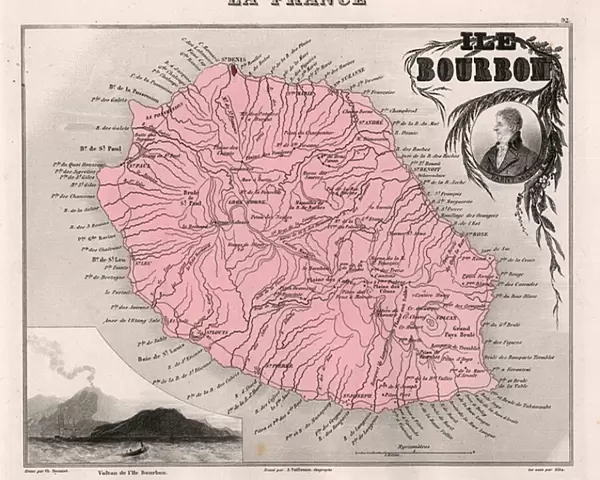
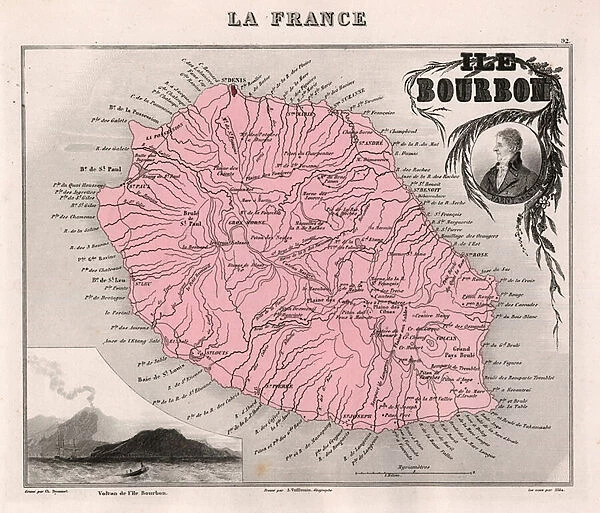
Canvas Print : Ile de La Reunion (Bourbon Island), DOM (overseas department or overseas department) - France and its Colonies. Atlas illustrates one hundred and five maps from the maps of the depot of war, bridges and footwear and the Navy by M. VUILLEMIN. 1876
, DOM (overseas department or overseas department) - France and its Colonies. Atlas illustrates one hundred and five maps from the maps of the depot of war, bridges and footwear and the Navy by M. VUILLEMIN. 1876")
, DOM (overseas department or overseas department) - France and its Colonies. Atlas illustrates one hundred and five maps from the maps of the depot of war, bridges and footwear and the Navy by M. VUILLEMIN. 1876")

![]()
Canvas Prints from Fine Art Finder
Ile de La Reunion (Bourbon Island), DOM (overseas department or overseas department) - France and its Colonies. Atlas illustrates one hundred and five maps from the maps of the depot of war, bridges and footwear and the Navy by M. VUILLEMIN. 1876
XEE4144389 Ile de La Reunion (Bourbon Island), DOM (overseas department or overseas department) - France and its Colonies. Atlas illustrates one hundred and five maps from the maps of the depot of war, bridges and footwear and the Navy by M. VUILLEMIN. 1876. by Vuillemin, Alexandre (1812-1886); Private Collection; (add.info.: Ile de La Reunion (Bourbon Island), DOM (overseas department or overseas department) - France and its Colonies. Atlas illustrates one hundred and five maps from the maps of the depot of war, bridges and footwear and the Navy by M. VUILLEMIN. 1876.); Stefano Bianchetti; French, out of copyright
Media ID 25139130
© Stefano Bianchetti / Bridgeman Images
Atlas Book Dom Tom Mascareignes Islands Reunion Island Geographical Map
20"x16" (51x41cm) Canvas Print
Discover the captivating beauty of Ile de La Réunion, also known as Bourbon Island, with our exquisite Canvas Print from Media Storehouse. This stunning artwork, titled "Ile de La Réunion (Bourbon Island), DOM (overseas department or overseas department) - France and its Colonies," is an 1876 map illustration from the depot of war, bridges and footwear and the Navy by M. VUILLEMIN. Meticulously reproduced, this fine art print showcases intricate details and vibrant colors, bringing the rich history of France's overseas departments to your home or office. Experience the allure of this unique piece with our premium canvas material and high-quality printing techniques. Transform any space into a captivating gallery with our Ile de La Réunion Canvas Print. © Stefano Bianchetti, XEE4144389.
Delivered stretched and ready to hang our premium quality canvas prints are made from a polyester/cotton blend canvas and stretched over a 1.25" (32mm) kiln dried knot free wood stretcher bar. Packaged in a plastic bag and secured to a cardboard insert for safe transit.
Canvas Prints add colour, depth and texture to any space. Professionally Stretched Canvas over a hidden Wooden Box Frame and Ready to Hang
Estimated Product Size is 50.8cm x 40.6cm (20" x 16")
These are individually made so all sizes are approximate
Artwork printed orientated as per the preview above, with landscape (horizontal) orientation to match the source image.
FEATURES IN THESE COLLECTIONS
> Europe
> France
> Heritage Sites
> Pitons, cirques and remparts of Reunion
> Maps and Charts
> Related Images
> Services
> Royal Navy
> Fine Art Finder
> Artists
> Alexandre Vuillemin
> Fine Art Finder
> Artists
> Walery (1863-1935)
EDITORS COMMENTS
This print showcases a historical map of Ile de La Reunion (Bourbon Island), a French overseas department located in the Mascarene Islands. The map is part of an atlas compiled by M. Vuillemin in 1876, featuring one hundred and five meticulously detailed maps from various sources including the depot of war, bridges, footwear, and the Navy. The intricate engravings on this geographical map offer a glimpse into the past, revealing the colonial influence of France on this tropical island paradise. The vibrant colors used to depict land masses and water bodies bring life to this vintage artwork. Ile de La Reunion (Bourbon Island) holds a significant place in history as it served as an important trading post during colonial times. This print allows us to explore its geography and understand its strategic importance within France's colonies. The artist behind this engraving, Stefano Bianchetti, has skillfully captured every detail with precision and accuracy. Through his work, he invites us to delve into the rich history and cultural heritage of Ile de La Reunion. As we admire this piece of artistry from our private collection, we are transported back in time to witness how cartography played a vital role in shaping nations and exploring new territories. It serves as a reminder that even today, maps continue to be powerful tools for understanding our world's past while guiding us towards future discoveries.
MADE IN AUSTRALIA
Safe Shipping with 30 Day Money Back Guarantee
FREE PERSONALISATION*
We are proud to offer a range of customisation features including Personalised Captions, Color Filters and Picture Zoom Tools
SECURE PAYMENTS
We happily accept a wide range of payment options so you can pay for the things you need in the way that is most convenient for you
* Options may vary by product and licensing agreement. Zoomed Pictures can be adjusted in the Cart.