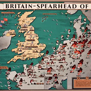
Canvas Print > Europe > United Kingdom > England > Maps
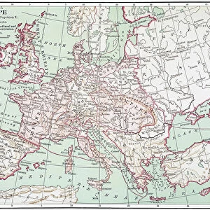
Canvas Print : 1643, antiquity, archival, british isles, cartography, england, europe, geographical


![]()
Canvas Prints from Fine Art Storehouse
1643, antiquity, archival, british isles, cartography, england, europe, geographical
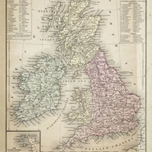
1643, antiquity, archival, british isles, cartography, england, europe, geographical, geography, historical, map, nobody, old-fashioned, text, uk, vintage, Antique Maps, 89687337
Unleash your creativity and transform your space into a visual masterpiece!
Hemera Technologies
Media ID 14761238
© Getty Images
Antiquity British Isles Geographical Geography Text 1643
20"x16" (51x41cm) Canvas Print
"Step back in time with our exquisite Canvas Print from Media Storehouse's Fine Art Storehouse collection. Featuring an intricately detailed antique map of the British Isles and Europe from 1643, this archival print transports you to a bygone era. With its rich cartographic depictions of England, Scotland, Wales, and the continent, this vintage geographical masterpiece is perfect for adding historical charm to any room. Crafted using premium canvas and high-definition printing technology, this Canvas Print is an investment in timeless beauty and a testament to the fascination of geography and history."
Delivered stretched and ready to hang our premium quality canvas prints are made from a polyester/cotton blend canvas and stretched over a 1.25" (32mm) kiln dried knot free wood stretcher bar. Packaged in a plastic bag and secured to a cardboard insert for safe transit.
Canvas Prints add colour, depth and texture to any space. Professionally Stretched Canvas over a hidden Wooden Box Frame and Ready to Hang
Estimated Product Size is 50.8cm x 40.6cm (20" x 16")
These are individually made so all sizes are approximate
Artwork printed orientated as per the preview above, with landscape (horizontal) orientation to match the source image.
FEATURES IN THESE COLLECTIONS
> Europe
> Related Images
> Europe
> United Kingdom
> England
> Maps
> Europe
> United Kingdom
> England
> Posters
> Europe
> United Kingdom
> England
> Related Images
> Europe
> United Kingdom
> Maps
> Maps and Charts
> Early Maps
> Maps and Charts
> Related Images
> Fine Art Storehouse
> Map
> Historical Maps
EDITORS COMMENTS
This print takes us back in time to the year 1643, immersing us in the antiquity and historical significance of the British Isles. The archival map, meticulously crafted with cartography expertise, showcases England and its place within Europe. Its vintage charm is evident through its old-fashioned text and intricate details that transport us to a bygone era. The map's geographical accuracy offers a glimpse into the past, allowing us to explore the landscapes and boundaries as they were centuries ago. It serves as a valuable resource for historians, researchers, or anyone with an interest in understanding how the British Isles fit into Europe's tapestry during this period. The absence of people in this image emphasizes its focus on geography rather than human activity. Instead, our attention is drawn to every line and contour that forms this remarkable piece of artistry. As we delve deeper into its rich history, we can appreciate both the craftsmanship behind it and Hemera Technologies' commitment to preserving these antique maps. Whether displayed in a personal collection or used for educational purposes, this print from Fine Art Storehouse captures not only an exquisite piece of cartographic heritage but also invites viewers to embark on a journey through time itself.
MADE IN AUSTRALIA
Safe Shipping with 30 Day Money Back Guarantee
FREE PERSONALISATION*
We are proud to offer a range of customisation features including Personalised Captions, Color Filters and Picture Zoom Tools
SECURE PAYMENTS
We happily accept a wide range of payment options so you can pay for the things you need in the way that is most convenient for you
* Options may vary by product and licensing agreement. Zoomed Pictures can be adjusted in the Cart.