Canvas Print > North America > Canada > Maps
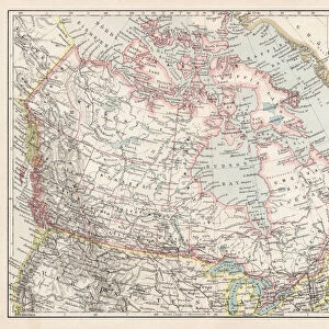
Canvas Print : Map of British provinces Canada 1889


![]()
Canvas Prints from Fine Art Storehouse
Map of British provinces Canada 1889
Comprehensive Geography by James Monteith - American Book Company 1882, 1889
Unleash your creativity and transform your space into a visual masterpiece!
THEPALMER
Media ID 18357249
30"x20" (76x51cm) Canvas Print
Step back in time with our exquisite Canvas Print of the Map of British Provinces in Canada from 1889, beautifully reproduced from the Comprehensive Geography book by James Monteith published by The American Book Company. This vintage map, titled "British Provinces of North America" by THEPALMER, showcases the geography of Canada during an era of significant expansion and exploration. The intricate details of the map are brought to life with our premium canvas printing process, creating a stunning piece of historical art for your home or office. Add a touch of history and character to any space with this captivating Canvas Print from Media Storehouse's Fine Art collection.
Delivered stretched and ready to hang our premium quality canvas prints are made from a polyester/cotton blend canvas and stretched over a 1.25" (32mm) kiln dried knot free wood stretcher bar. Packaged in a plastic bag and secured to a cardboard insert for safe transit.
Canvas Prints add colour, depth and texture to any space. Professionally Stretched Canvas over a hidden Wooden Box Frame and Ready to Hang
Estimated Product Size is 76.2cm x 50.8cm (30" x 20")
These are individually made so all sizes are approximate
Artwork printed orientated as per the preview above, with landscape (horizontal) orientation to match the source image.
FEATURES IN THESE COLLECTIONS
> Maps and Charts
> Related Images
> North America
> Canada
> Maps
> North America
> Canada
> Related Images
> Fine Art Storehouse
> Map
> Historical Maps
EDITORS COMMENTS
In this print titled "Map of British Provinces Canada 1889" we are transported back in time to an era when cartography was both a science and an art form. The map, originally featured in James Monteith's Comprehensive Geography published by the American Book Company in 1882 and updated in 1889, offers us a glimpse into the intricate details of Canada's provinces during that period. The image showcases the craftsmanship and precision with which maps were created before the advent of digital technology. Each province is meticulously outlined, revealing its unique shape and boundaries. The various cities, towns, rivers, lakes, and mountain ranges are intricately labeled, providing valuable geographical information for explorers or scholars alike. As we study this historical artifact captured by THEPALMER from Fine Art Storehouse, our imagination takes flight as we envision early settlers navigating through vast wildernesses or traders charting their course along well-worn trade routes. We can almost hear the echoes of conversations about territorial disputes or discussions on how these lands would evolve over time. This print serves as a reminder not only of our rich history but also of the importance of preserving such invaluable artifacts. It invites us to appreciate the dedication and skill required to create such detailed maps while igniting curiosity about how our world has transformed since then.
MADE IN AUSTRALIA
Safe Shipping with 30 Day Money Back Guarantee
FREE PERSONALISATION*
We are proud to offer a range of customisation features including Personalised Captions, Color Filters and Picture Zoom Tools
SECURE PAYMENTS
We happily accept a wide range of payment options so you can pay for the things you need in the way that is most convenient for you
* Options may vary by product and licensing agreement. Zoomed Pictures can be adjusted in the Cart.