Metal Print > North America > Canada > Maps
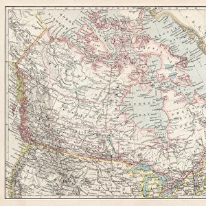
Metal Print : Map of British provinces Canada 1889


![]()
Metal Prints from Fine Art Storehouse
Map of British provinces Canada 1889
Comprehensive Geography by James Monteith - American Book Company 1882, 1889
Unleash your creativity and transform your space into a visual masterpiece!
THEPALMER
Media ID 18357249
14"x11" (28x35cm) Metal Print
Step back in time with our stunning Metal Print of the Map of British Provinces in Canada from 1889, brought to you by THEPALMER from the Fine Art Storehouse. This intricately detailed map, originally published in Comprehensive Geography by James Monteith with the American Book Company, showcases the British territories in Canada during a pivotal period in its history. The vibrant colors and sharp lines are beautifully preserved in our high-quality Metal Print, making it a captivating addition to any home or office decor. Relive the history and geography of Canada with this unique and eye-catching piece of art.
Our Metal Prints feature rounded corners and rear fixings for easy wall mounting. Images are directly printed onto a lightweight, high quality 5mm thick, durable metallic surface for a vivid and vibrant finish. Available in 2 sizes, 28x35cm (14x11) and 50x40cm (20x16). The unique material is fade, moisture, chemical and scratch resistant to help ensure this art lasts a lifetime.
Made with durable metal and luxurious printing techniques, metal prints bring images to life and add a modern touch to any space
Estimated Product Size is 35.5cm x 27.9cm (14" x 11")
These are individually made so all sizes are approximate
Artwork printed orientated as per the preview above, with landscape (horizontal) or portrait (vertical) orientation to match the source image.
FEATURES IN THESE COLLECTIONS
> Fine Art Storehouse
> Map
> Historical Maps
> Maps and Charts
> Related Images
> North America
> Canada
> Maps
> North America
> Canada
> Related Images
EDITORS COMMENTS
In this print titled "Map of British Provinces Canada 1889" we are transported back in time to an era when cartography was both a science and an art form. The map, originally featured in James Monteith's Comprehensive Geography published by the American Book Company in 1882 and updated in 1889, offers us a glimpse into the intricate details of Canada's provinces during that period. The image showcases the craftsmanship and precision with which maps were created before the advent of digital technology. Each province is meticulously outlined, revealing its unique shape and boundaries. The various cities, towns, rivers, lakes, and mountain ranges are intricately labeled, providing valuable geographical information for explorers or scholars alike. As we study this historical artifact captured by THEPALMER from Fine Art Storehouse, our imagination takes flight as we envision early settlers navigating through vast wildernesses or traders charting their course along well-worn trade routes. We can almost hear the echoes of conversations about territorial disputes or discussions on how these lands would evolve over time. This print serves as a reminder not only of our rich history but also of the importance of preserving such invaluable artifacts. It invites us to appreciate the dedication and skill required to create such detailed maps while igniting curiosity about how our world has transformed since then.
MADE IN AUSTRALIA
Safe Shipping with 30 Day Money Back Guarantee
FREE PERSONALISATION*
We are proud to offer a range of customisation features including Personalised Captions, Color Filters and Picture Zoom Tools
SECURE PAYMENTS
We happily accept a wide range of payment options so you can pay for the things you need in the way that is most convenient for you
* Options may vary by product and licensing agreement. Zoomed Pictures can be adjusted in the Cart.