Canvas Print > Maps and Charts > Willem Janszoon Blaeu
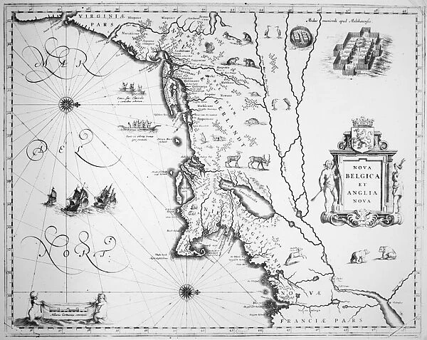
Canvas Print : MAP: NEW ENGLAND, 1635. Line engraving of Nova Belgica et Anglia Nova from Willem


![]()
Canvas Prints from Granger
MAP: NEW ENGLAND, 1635. Line engraving of Nova Belgica et Anglia Nova from Willem
MAP: NEW ENGLAND, 1635.
Line engraving of Nova Belgica et Anglia Nova from Willem Janszoon Blaeus Atlas of 1635, showing the coast of North America from Virginia to the St. Lawrence River
Granger holds millions of images spanning more than 25,000 years of world history, from before the Stone Age to the dawn of the Space Age
Media ID 12321169
1635 Atlas Bear Beaver Blaeu Coast Colony Deer Janszoon New England Portolan Chart Ship United States Village Willem Nova
20"x16" (51x41cm) Canvas Print
Discover the rich history of New England in 1635 with our stunning Canvas Print of "MAP: NEW ENGLAND, 1635. Line engraving of Nova Belgica et Anglia Nova from Willem Janszoon Blaeus." This intricately detailed map, sourced from Granger Art on Demand, offers a captivating glimpse into the early exploration of North America. The line engraving depicts the coastline from Virginia to the St. Lawrence River, revealing the known territories of the time. Bring history to life in your home or office with this beautiful and authentic work of art, expertly printed on high-quality canvas for lasting vibrancy and detail.
Delivered stretched and ready to hang our premium quality canvas prints are made from a polyester/cotton blend canvas and stretched over a 1.25" (32mm) kiln dried knot free wood stretcher bar. Packaged in a plastic bag and secured to a cardboard insert for safe transit.
Canvas Prints add colour, depth and texture to any space. Professionally Stretched Canvas over a hidden Wooden Box Frame and Ready to Hang
Estimated Product Size is 50.8cm x 40.6cm (20" x 16")
These are individually made so all sizes are approximate
Artwork printed orientated as per the preview above, with landscape (horizontal) orientation to match the source image.
FEATURES IN THESE COLLECTIONS
> Maps and Charts
> Willem Janszoon Blaeu
> Granger Art on Demand
> Maps
EDITORS COMMENTS
This print titled "MAP: NEW ENGLAND, 1635" takes us back in time to the early days of American colonization. The line engraving, sourced from Willem Janszoon Blaeus Atlas of 1635, offers a detailed depiction of the North American coast stretching from Virginia to the St. Lawrence River. The image showcases the rugged beauty of this untamed land, with its dense forests and pristine rivers. A ship can be seen sailing along the coastline, symbolizing the arrival of European explorers and settlers seeking new opportunities across the Atlantic. Intriguingly, a diverse array of wildlife is also featured in this map. Majestic bears roam freely through thickets while graceful deer graze peacefully nearby. Beavers busily construct their dams along meandering streams, highlighting their vital role in trade and commerce during that era. A charming village nestled by the shore stands as evidence that human presence has begun to shape this landscape. This settlement represents one among many colonies established by brave pioneers who sought fortune and freedom on these shores. Overall, this historic print not only serves as an educational tool but also evokes a sense of wonder about New England's past. It reminds us how far we have come since those early days when America was still being discovered and shaped into what it is today - a nation built upon exploration, resilience, and diversity.
MADE IN AUSTRALIA
Safe Shipping with 30 Day Money Back Guarantee
FREE PERSONALISATION*
We are proud to offer a range of customisation features including Personalised Captions, Color Filters and Picture Zoom Tools
SECURE PAYMENTS
We happily accept a wide range of payment options so you can pay for the things you need in the way that is most convenient for you
* Options may vary by product and licensing agreement. Zoomed Pictures can be adjusted in the Cart.