
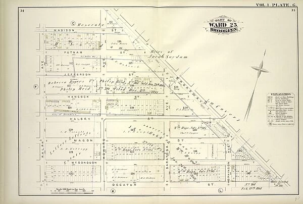
Canvas Print : Vol. 1. Plate, G. Map bounded by Madison St


![]()
Canvas Prints from Liszt Collection
Vol. 1. Plate, G. Map bounded by Madison St
Vol. 1. Plate, G. Map bounded by Madison St. Broadway, Decatur St. Ralph Ave.; Including Putman St. Jefferson St. Hancock St. Halsey St. Macon St. Mc Donough St. Howard Ave. Saratoga Ave. Hopkinson Ave
Liszt Collection of nineteenth-century engravings and images to browse and enjoy
Media ID 12672903
© Quint Lox Limited
Broadway Cartographic Historic Map Vintage Map Vol 1 Plate
30"x20" (76x51cm) Canvas Print
Bring the timeless beauty of the Liszt Collection to your home with our Canvas Prints. This particular print features Volume 1, Plate G, "G. Map bounded by Madison St." from the collection. The map includes notable streets such as Broadway, Decatur St., Ralph Ave., Putnam St., Jefferson St., Hancock St., Halsey St., Macon St., McDonough St., and Howard Ave. (Saratoga Ave.). Each Canvas Print is meticulously crafted with high-quality materials, ensuring vibrant colors and sharp details. Transform your space into a gallery with this stunning addition from Media Storehouse.
Delivered stretched and ready to hang our premium quality canvas prints are made from a polyester/cotton blend canvas and stretched over a 1.25" (32mm) kiln dried knot free wood stretcher bar. Packaged in a plastic bag and secured to a cardboard insert for safe transit.
Canvas Prints add colour, depth and texture to any space. Professionally Stretched Canvas over a hidden Wooden Box Frame and Ready to Hang
Estimated Product Size is 76.2cm x 50.8cm (30" x 20")
These are individually made so all sizes are approximate
Artwork printed orientated as per the preview above, with landscape (horizontal) orientation to match the source image.
EDITORS COMMENTS
This vintage map print, titled "Vol. 1. Plate, G. Map bounded by Madison St" is a captivating piece that offers a glimpse into the rich history of New York City. The intricate details and careful cartographic work showcase the city's layout during a specific era. The map encompasses an area bounded by Madison Street, Broadway, Decatur Street, and Ralph Avenue, including notable streets like Putman Street, Jefferson Street, Hancock Street, Halsey Street, Macon Street, Mc Donough Street, Howard Avenue, Saratoga Avenue, and Hopkinson Avenue. As you explore this historic map from the Liszt Collection with its faded hues and delicate lines representing various streets and landmarks of old New York City come to life before your eyes. It transports you back in time to an era when horse-drawn carriages traversed these very streets. With its exquisite attention to detail and accurate representation of the city's geography at that time period; this vintage map serves as both a decorative piece for any space as well as an educational tool for those interested in understanding how the city has evolved over time
MADE IN AUSTRALIA
Safe Shipping with 30 Day Money Back Guarantee
FREE PERSONALISATION*
We are proud to offer a range of customisation features including Personalised Captions, Color Filters and Picture Zoom Tools
SECURE PAYMENTS
We happily accept a wide range of payment options so you can pay for the things you need in the way that is most convenient for you
* Options may vary by product and licensing agreement. Zoomed Pictures can be adjusted in the Cart.